A Web Mapping Application can use one or more content sources. Each source contains one or more map layers. A map layer is a type of data shown on the map, such as roads, cities or a satellite image.
Within the Hudson River Watershed Mapping Application users are able to view the list of the contents of the map, turn on and off layers, and examine the symbols for layers.
To examine the map contents:
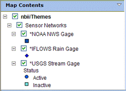
- In the Console, display the Map Contents item, if necessary, by clicking the down arrow for Contents.
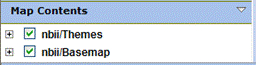
- When Map Contents opens, only the top-level content items may be visible.
- Click the plus button
 next to a content item to display the layers within it.
 - A check-box next to the layer indicates whether the layer is currently turned on. These check-boxes may not be present in your application.
- If enabled, you can click the check-box next to the layer name to turn the layer on or off. The map automatically redraws to reflect the changes in layer visibility.
- Some layers may not be visible at the current map scale (zoom level). These layers are called scale dependent. You may need to zoom the map in or out to see a particular layer displayed, even if its check-box is checked to draw.
- If layers have a plus button next to the name, you can expand the layer to display a legend for the layer. The legend may display a single symbol
or multiple symbols for the layer.