 Reproduced, with permission, from:
Washino, R. K., and B. L. Wood. n.d. Application of remote sensing to
vector arthropod surveillance and control. American Journal of
Tropical Medicine and Hygiene. In press.
Reproduced, with permission, from:
Washino, R. K., and B. L. Wood. n.d. Application of remote sensing to
vector arthropod surveillance and control. American Journal of
Tropical Medicine and Hygiene. In press.
Running head: REMOTE SENSING AND VECTOR SURVEILLANCE
Robert K. WashinoDepartment of Entomology
University of California, Davis
Byron L. Wood
TGS Technology, Inc.
NASA Ames Research Center
Moffett Field, California
Corresponding Author:
R. K. Washino
Professor of Entomology
Department of Entomology
University of California
Davis, CA 95616
(916) 752-6970
(916) 752-1537 FAX
Abstract: A need exists to further develop new technologies, such as remote sensing and geographic information systems analysis, for estimating arthropod vector abundance in aquatic habitats and predicting adult vector population outbreaks. A brief overview of remote sensing technology in vector surveillance and control is presented, and suggestions are made on future research opportunities in light of current and proposed remote sensing systems.
Introduction
During the 1960's, views of the earth provided by images from early meteorological satellites and the United State's manned spacecraft program stimulated interest in developing a series of civilian earth resource satellites. The first of these satellites, the Earth Resources Technology Satellite (ERTS-1), was launched by the National Aeronautics and Space Administration (NASA) on July 23, 1972.* In the 20 years since then, the U.S. and a number of other nations have continued to develop and launch increasingly sophisticated remote sensing systems that now provide regular, global coverage of the earth's surface. Today, remote sensing data acquired by these systems are commonly used in such diverse disciplines as agriculture, forestry, geology, and environmental planning. However, the use of these data for monitoring environmental conditions that influence the patterns of arthropod vector-borne diseases has been limited. Fortunately, from the standpoint of developing regional vector surveillance and control programs, this situation is changing. This paper will (1) summarize the current status of malaria and disease vector surveillance needs, (2) present a brief overview of remote sensing technology, and (3) review past, present and future applications of remote sensing in vector surveillance and control.
Background
Currently, nearly half of the earth's people live in tropical or temperate regions where they may be a risk to one or more vector-borne diseases. Approximately 2.1 billion people, in over 100 countries, are at risk of malaria alone[1]. In recent years, the situation has been improving in some areas while worsening in others. However, overall prevalence continues to increase in many parts of Africa, Asia, and the Americas[2].
The growing prevalence of malaria worldwide has led many agencies and institutions, including the World Health Organization (WHO), to call for the development of new and innovative approaches to malaria surveillance and control[3]. An essential element in this development is the recognition of the variability of environmental and epidemiological parameters that influence the patterns of malaria vector populations and disease transmission risk. During its larval stage, the vector of malaria requires an aquatic environment frequently described in terms of vegetation and water. In many areas it is possible to reduce the prevalence of malaria by locating and treating these larval habitats[4]. Unfortunately, current techniques for locating larval habitats and monitoring mosquito populations are labor-intensive, time-consuming, and impractical over large areas.
Malaria surveillance most often includes monitoring (1) the disease in human populations, (2) patterns of drug resistance in parasites, and (3) intensity of transmission by vector populations. In malaria control programs where vector control constitutes an important component in the overall strategy, a surveillance system to accurately estimate vector abundance is essential. Such programs most often focus on quantifying important epidemiologic parameters of the anopheline adult population, but a basic understanding of the aquatic stages of vector biology is also extremely relevant to malaria control[1]. Theoretically, maintaining a reliable system of monitoring the larval population of a vector species allows at least some time (minimal as it might be) to exert control measures over the emerging adult population, or under certain circumstances, deciding that larviciding may be more appropriate than adulticiding.
One of the major barriers to developing an acceptable vector surveillance program of any sort is, however, in designing and implementing a sampling system to adequately monitor the vector larval population. For example, in California, where 100,000 - 240,000 ha of land are devoted to rice cultivation each year, the following three factors make the implementation of any conventional larval surveillance program a near logistical impossibility: (1) the magnitude of the habitat (i.e., a single rice field may vary in size from five to several hundred ha; (2) the extremely low density of mosquito larvae in rice fields (e.g., with Anopheles freeborni, at least 1150 dips would be required to achieve a reliability level of 0.25 for mean population densities of 0.1 larvae per dip; (3) the short length of the aquatic larval stage which may be as brief as 5 to 7 days in culicines and 7 to 9 days in anophelines. Results of field studies (Christensen, J.B., and R.K. Washino, University of California, Davis, unpubl.; Pitcairn, J.J., LT. Wilson, R.K. Washino and E. Rejmankova, NASA Ames and University of California, Davis. unpubl.) reaffirm the need to develop new technologies, such as remote sensing and geographic information systems (GIS) analysis, for estimating vector abundance in aquatic habitats.
At both regional and local scales, the spatial and temporal patterns of anopheline vector populations are strongly influenced by elevation, temperature, precipitation and humidity[5]. Individually, these factors are not easily characterized using remote sensing directly. However, the vegetation of an area reflects the integration of all these factors, and this integration can be sensed remotely. Because remote sensing data acquired in the visible and infrared regions of the electromagnetic spectrum are sensitive to subtle differences in vegetation and water, they provide a potential tool for surveying large areas to identify vector habitats and direct control measures.
Remote sensing
We have all become accustomed to the "birds-eye" view of the earth provided by photographs and images acquired from aircraft as well as from manned and un-manned spacecraft. However, in order to understand how remote sensing data can be applied in disease vector surveillance, it is necessary to review a few basic principles.
Remote sensing has been defined as: "... the science and art of obtaining information about an object, area, or phenomenon through the analysis of data acquired by a device that is not in contact with the object, area, or phenomenon under investigation."[6] Traditional methods of acquiring remote sensing data employ cameras or a variety of electronic sensing devices that can be mounted on platforms located anywhere from a few meters to thousands of kilometers from the object, area, or phenomenon of interest.
The "science" of remote sensing rests on the fact that every object, area, or phenomenon reflects and emits energy at specific and distinctive wavelengths of the electromagnetic spectrum. Acquisition of remote sensing data for environmental monitoring is generally restricted to the visible, infrared, and microwave regions of this spectrum. The "art" of remote sensing lies in the ability to exploit this basic matter and energy relationship, in order to identify, map, or monitor features of interest. Passive sensors include photography and muitispectral scanners which record reflected or emitted energy. In contrast, active sensors such as radar transmit short bursts of microwave energy to "illuminate" the surface; these systems then record the return signal from within their field of view.
Several characteristics of remote sensing data make them especially well suited for studying environmental processes: (1) imagery acquired from aircraft or satellite platforms provides a regional perspective of the earth's surface; (2) sensors can be calibrated to record in spectral regions beyond those to which the human eye is sensitive; (3) data are commonly available in digital format for computer analysis and integration with other digital databases; and (4) they provide a historical record of conditions for a particular area or region.
Aerial black-and-white, color, and color-infrared photography are the most commonly used forms of passive remote sensing. Black-and-white film records reflected energy as a continuous gray scale in the visible or near-infrared regions, between 0.4 and 0.9
. In color photography, reflected energy is recorded as gray scales on three separate film layers that, like the human eye, are sensitive to the blue (0.4 - 0.5
m), green (0.5 - 0.6
m), and red (0.6 - 0.7
m) regions. In contrast to normal color film,, color-infrared is manufactured to record in the green, red, and near-infrared regions.
The sensitivity of photographic film is restricted to no more than three spectral regions between 0.3 and 0.9 m at any one time. However, using an electronic multispectral scanner** it is possible to extend this range from the ultraviolet (0.3
m) through the infrared and thermal (14.0
m) regions. Multispectral scanners can be calibrated to simultaneously record in many discrete spectral regions, and because they can record and transmit data electronically (i.e., in digital format), they are well suited for use on satellite platforms.
The digital image generated by multispectral scanner systems is actually a two-dimensional array of discrete picture elements, or pixels. The sensors for each array are calibrated to record reflected and/or emitted energy in a specific spectral region. Individual pixels in this array may be from a few meters to several kilometers square. The value (digital number, DN) of each pixel, which correspond to photographic gray levels, represent the average reflectance over the ground area being measured. Multispectral scanners are therefore able to record more subtle differences in surface reflectance than photographic systems. Depending on user needs, the data can be processed for either visual or computer analysis.
Radar systems differ from other remote sensing systems in that they provide their own source of energy within the microwave (1 mm to 1 m) portion of the electromagnetic spectrum to illuminate features of interest. Microwave reflections or emissions from features bear no direct relationship to their counterparts in the visible or thermal regions of the electromagnetic spectrum, and therefore provide a markedly different picture of the surface[6]. However, such systems have an advantage over passive systems in that they can be used day or night under all weather conditions. The interaction of radar wavelengths and surface features, such as vegetation, is complex and involves plant size, density, and background soil conditions. In general, the shorter wavelengths are best for sensing canopy characteristics, whereas longer wavelengths respond to larger features such as a tree trunks and limbs.
The interpretation of aerial photography, or enhanced multispectral imagery that has been photographically processed, involves the visual identification of objects and the determination of their meaning or significance based on color, shape, size, shadow, tone, texture, pattern, and location. A skilled interpreter is able to recognize objects on aerial photography by consciously or unconsciously synthesizing a few or all of these factors. This skill is developed through experience looking at photography and a good background or field knowledge of the objects of interest. In contrast, analysis of digital multispectral scanner data requires both computer processing and human interpretation of the results of the processing. Specialized computer programs have been developed to handle the large volume of digital data (e.g., a Landsat TM scene contains nearly 252 million digital values corresponding to individual pixels) generated by multispectral scanners. These include the capability to geographically register, enhance, transform, and classify the data based on its spectral characteristics. The results of these processes are then most frequently analyzed using statistical or visual methods of interpretation. It should be kept in mind that the analysis and interpretation process provides the user with discipline-specific information and is therefore the means to an end, not an end in itself. The promise of remote sensing technology is to allow the user to extrapolate local-level measurements to a regional scale and therefore to discern spatial and temporal patterns that could not otherwise be seen.
Selecting the appropriate remote sensing data for a given study requires consideration of the data's spatial, spectral, and temporal resolution. The potential user needs to evaluate alternative products in terms of the objects, areas, or phenomena of interest. In this regard, it is important to determine if the data are being acquired (1) at an appropriate spatial scale, (2) in spectral regions that will allow features of interest to be distinguished from their surroundings, and (3) at appropriate times of the year to achieve the goals of the study.
Current Remote Sensing Systems
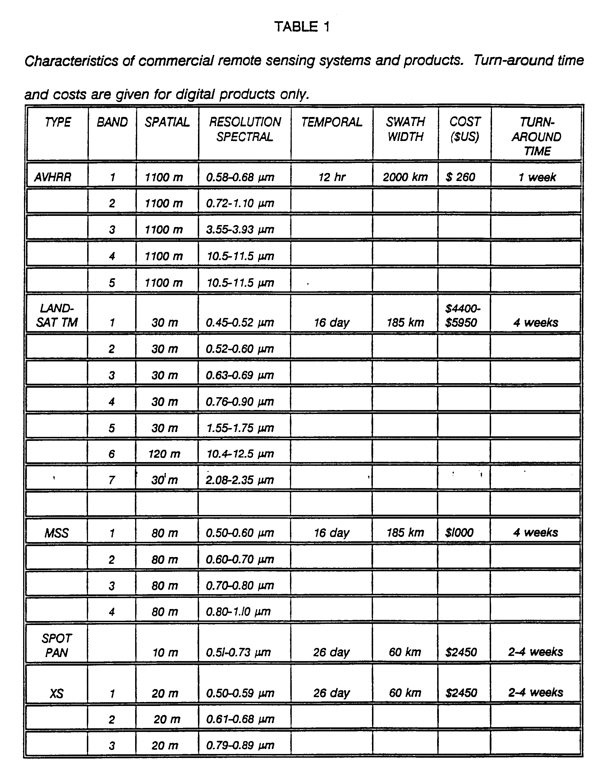
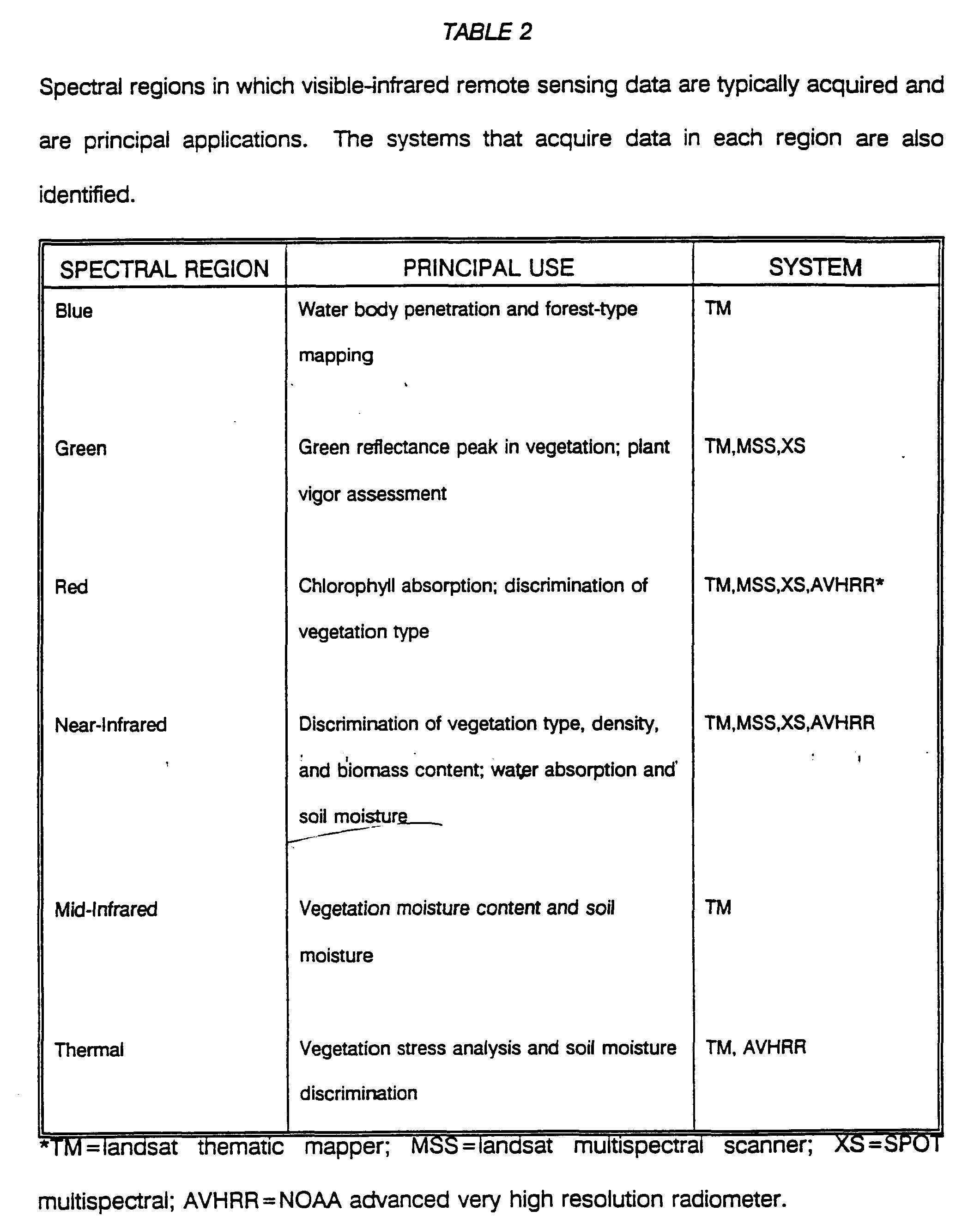
At the present time there are a number of civilian satellite remote sensing systems operated by the U.S., France, Japan, Russia, India, and the European Space Agency (ESA) that provide regular coverage over much of the earth's surface. The systems listed in Table 1 are the primary ones that acquire visible and infrared digital data covering a range of spatial, spectral and temporal resolutions. Each of these systems has bands located in regions necessary for characterizing land cover, including difference between vegetation, water, and soil moisture (Table 2).
All of the studies discussed in this paper have used remote sensing data that are commercially available. From the standpoint of developing an operational surveillance or control program, potential users need to know if appropriate data will continue to be available beyond the initial study. Although a review of all available and proposed remote sensing systems is beyond the scope of this paper, it is important to comment on some of the more commonly available types of remote sensing data.
Beginning in the 1930's, quality standards were developed for the acquisition and processing of black-and-white photography used for soil and crop inventory programs. Similar standards were subsequently developed for color and color-infrared photography used in forestry and resource mapping. Large-scale black-and-white-photography continues to be acquired on a regular basis by the USDA, USGS, and NASA in a variety of environmental applications.
The launch of ERTS-1 in 1972 provided the first opportunity to acquire global remote sensing data on a regular basis. The MSS scanners carried by ERTS-1 and subsequent Landsats 2, 3, 4 and 5 have provided uninterrupted acquisition of 4-channel data at a nominal resolution for over 20 years Beginning in 1982, a 30-m 7-channel Thematic Mapper (TM) scanner was added to the Landsats 4 and 5 platforms. Landsat 6 is scheduled to be launched in 1993 and will provide continuity of TM data with Landsats 4 and 5. This platform will also add several new capabilities, including a 15-m panchromatic band that should be useful for detailed mapping. Planning for the development of the next satellite in this series (Landsat 7) is already underway. Landsats 6 and 7 will provide continuity of data acquisition into the 21st century.
A number of satellites have been launched as part of the continuing NOM series of meteorological platforms. The 5-channel AVHRR muitispectral scanner was first included on NOAA-6 in 1979. Since that time there have been five additional platforms that have supported a similar AVHRR sensor. Current plans call for small changes in this sensor to improve its capability to monitor worldwide vegetation patterns.
In the early 1980's the French began development of the SPOT series of remote sensing satellites. The first in this series, SPOT 1, was launched in February, 1986. This was followed by SPOT 2 in 1990, and plans call for the development and launch of three additional satellites during the next decade.
The systems described above represent current state-of-the-art capabilities in commercial remote sensing. Their evolution from low to high spatial and spectral resolution illustrates a trend common throughout this technology. Sensors carried by Landsat, NOAA and SPOT will continue to provide data into the 21st century. At the same time, new research capabilities continue to be developed by the U.S., ESA, Japan, and Canada.
In the U.S., NASA's Mission to Planet Earth will include the continued development of both existing and new remote sensing capabilities during the next decade. The new systems will include a series of satellites dedicated to discipline-specific requirements, called Earth Probes, and the Earth Observing System (EOS) that will include a series of multipurpose polar orbiting systems.
Outside the U.S., the primary focus has been on the development of all-weather Synthetic Aperture Radar (SAR) systems. In July 1991, the ESA launched the European Remote Sensing satellite (ERS-1) into a sun-synchronous polar orbit. Among other instruments, ERS-1 carries a SAR that will acquire 30-m resolution data every three days. Like ERS-1, the Japanese Earth Resources Satellite (JERS-1), launched in February 1992, supports an all weather SAR capability. However, the JERS-1 sensor package also includes a 7-channel optical sensor. Both JERS-1 sensors have a spatial resolution of 18 m.
The commercial and research systems described above illustrate some of the issues related to the application of remote sensing technologies to many existing environmental issues. Over the past 20 years, the technology of remote sensing has advanced at a rapid rate. Users in many disciplines are only now beginning to exploit the benefits of remote sensing technologies that were developed between 20 and 50 years ago. Fortunately, this gap between technology and application appears to be shrinking as new, more sophisticated and "user-friendly" applications software and analysis techniques, such as GIS, become available. Several public health investigators have demonstrated that a variety of remote sensing data can be used to characterize and monitor environmental factors that influence vector population dynamics and therefore provide valuable input to regional surveillance and control programs. The following examples may serve to illustrate some of the future opportunities where vector surveillance and control programs can benefit from this rapidly evolving technology.
Application of remote sensing data in disease vector surveillance and control
The use of aerial photography and manual interpretation techniques to identify and map disease vector habitats dates from 1949 when Audy[7] published a study on the distribution of scrub typhus in portions of southeast Asia. He determined that hyperendemic disease foci were associated with a vegetation type known as parang. Conventional black-and-white aerial photography was used to identify the distribution of parang vegetation, and therefore map the distribution of scrub typhus foci. The darker tone and rough texture of parang vegetation on this photography made it possible to distinguish it from surrounding types using visual interpretation techniques.
Similar visual interpretation techniques that exploit tone and texture have been used to identify and map landscape units associated with tick-borne encephalitis and tularemia in parts of the (former) Soviet Union (Personal communication from Korenberg, E., Gamaleya Institute for Epidemiology and Microbiology, Academy of Medical Sciences, Moscow, Russia). These studies were based on the concepts of landscape epidemiology and natural nidality of disease developed by Pavlovsky[8]. In 1973, NASA scientists used visual interpretation of color and color-infrared photography to map vegetation types associated with Aedes sollicitans breeding habitat near New Orleans, Louisiana[9]. High-altitude color-infrared photography was also used by Wagner et al.[10] in 1979 to produce a detailed map of Aedes breeding sites in a newly formed mosquito abatement district in Michigan. These habitat maps were subsequently used to direct control measures. More recently, Welch et al.[11,12] have used color-infrared aerial photography as a surveillance tool for Psorophora columbiae oviposition habitats in Texas rice fields. Their work was based on the visual interpretation of photography acquired during the summer and winter to map general land-use patterns and identify potential within-field breeding sites.
One of the first uses of multispectral scanner data was in the early 1970's when investigations from NASA and Mexico's Comision Nacional del Espacio Exterior developed a remote sensing approach for monitoring environmental parameters required for the propagation of the screwworm fly[13]. The remote sensing data used in this study were acquired by the ERTS and NOM satellites, as well as aircraft platforms. Although the results of this study indicated the general reliability of using satellite data for measuring environmental parameters associated with screwworm fly propagabon, the program never became operational. In 1976, Cibula[14] demonstrated that computer processing techniques could be used to classify airborne multispectral scanner data for identifying vegetation types associated with Aedes sollicitans in Louisiana. A similar approach was used by Barnes and Cibula[15] in 1979 to map Aedes sollicitans habitats throughout the entire Mississippi Delta.
In 1984, Cross et al.[16] used Landsat MSS data to describe the geographic (landscape) characteristics of sites in the Philippine Islands where cases of schistosoiasis were reported. These measurements were combined with temperature and precipitation data to estimate the probability of disease occurrence at specific locations. Like Cross, Hayes et al.[17] used Landsat MSS data to identify and map mosquito larval habitats in Nebraska and South Dakota based on their association with freshwater plant communities.
Linthicum et al.[18] used NOM AVHRR data to infer ecological parameters associated with Rift Valley Fever (RVF) in Kenya. Correlations between vegetation index values and ecological parameters indicated the possibility of predicting RVF viral activity in the mosquito vector. This work was extended by Pope et al.[19] who used Landsat TM to identify potential vector breeding sites known as dambos. High-resolution (1.6-m) multipolarization L-, C-, and X-band data were evaluated for discriminating between flooded and nonflooded breeding sites. The results of their research suggest that L-band (24.0 cm) data are best for making these distinctions. Finally, Landsat TM data were used by Hugh-Jones[20] to identify tick habitats on the island of Guadeloupe. He identified habitats that supported a range to tick populations based on calculated vegetation and moisture indices.
With few exceptions, these studies focused on the ability to use remote sensing to identify and map potential vector habitats based on vegetation, water, and soil. Not all vector habitat may, however, produce high vector populations. Therefore, from the standpoint of developing operational surveillance and control programs, it is necessary to go beyond habitat mapping and make predictions of when and where vector production and disease transmission risk will be greatest.
Predictive Studies
A few studies have attempted to take this next step and use remote sensing as input to predict both the spatial and temporal dynamics of vector populations and disease transmission risk. Interestingly, one of the first attempts at predictive modeling was the joint NASA-Mexico screwworm project of the early 1970's[13]. This study attempted to combine remote sensing measurements of vegetation, precipitation, and temperature to identify when and where conditions would be favorable for screwworm production. The studies by Cross[16], Linthicum et al.[18], and Pope et al.[19] also attempted to use remote sensing to predict the temporal as well as spatial patterns, of habitat development, vector populations, and disease transmission risk.
Malaria
At the present time, NASA's Global Monitoring and Human Health program is attempting to develop a remote sensing-based model to predict which villages in a portion of the southern coastal plain of Chiapas, Mexico, are "at risk" for malaria transmission. In this study, risk is defined by the proximity of a village to the breeding, feeding, and resting habitats required by the malaria vector Anopheles albimanus. In addition to this work, the following studies on African trypanosomiasis, Lyme disease, and riceland mosquito vectors of malaria are addressing the issue of predictive modelling and disease transmission risk based on the use of remote sensing and GIS technologies.
African trypanosomiasis
African trypanosomiasis, transmitted by the bite of tsetse flies, occurs in scattered foci throughout subsaharan Africa over an area in excess of 10 million sq. km where nearly 50 million people are at risk[21]. To identify, characterize, and map the patterns of tsetse fly habitat over such a large area would be almost impossible using anything other than satellite imagery, such as that acquired by the NOM AVHRR system. At this regional scale, Rogers and Randolph[22] related measurements of vegetation type, derived from AVHRR data, to field measurements of saturation deficit and tsetse fly population levels.***
These measurements of vegetation were derived using a ratio of the red and near-infrared AVHRR channels, and were considered as an integrated picture of the environmental factors that determine tsetse fly survival. Rogers and Randolph suggest that annually averaged AVHRR measurements of vegetation could be used to locate areas where tsetse fly survival rate would be highest and hence identify areas where humans were likely be at greatest risk of trypanosomiasis transmission.
Lyme disease
Lyme disease, a spirochetal infection transmitted to humans by Ixodes ticks, is currently the most prevalent, widely distributed and rapidly increasing vector-borne disease affecting human health in the U.S. and the north temperate regions of the globe. However, tick populations and disease incidence exhibit considerable spatial variability and depend on the interaction between humans, vertebrate reservoir hosts, and infected ticks. Landscape features such as patchiness (i.e., edges between brush, woodland and grassland and areas cleared for housing, roads, or trails) are likely locations for contact between humans, hosts and ticks. Remote sensing data have been used to identify and map landscape features associated with disease transmission risk.
In 1990, Daniel[23] used computer processing of Landsat MSS data to identify and map six landscape elements in a region of Czechoslovakia. These included coniferous forest, deciduous forest, mixed forest, water bodies, glades, and housing developments. The first three types were found to be associated with the presence of ticks, while the housing class was significant in assessing human exposure to ticks.
In the U.S., investigators from NASA's Ames Research Center and the New York Medical College (NYMC) are currently using high-altitude aerial photography and Landsat TM imagery to study the landscape epidemiology of Lyme disease along an urban-to-rural gradient in Westchester County, New York. In this suburban County, Lyme disease has been characterized as peridomestic, suggesting that transmission risk is greatest in areas where there is a mixture of deciduous forest and residential developments that bring ticks, hosts, and humans into contract.
Field studies of the seroprevalence of canine antibodies to Lyme disease (an indirect measure of human disease risk) indicate that exposure is not uniform, but increases by municipality from south-to-north along the Westchester County urban-to-rural gradient[24]. Landsat TM data were processed to identify key land cover types, and it was determined that composition also varied by municipality from south-to-north. The land cover classification and canine seroprevalence data were combined in a GIS and correlated by municipality. It was determined that canine seroprevalence was positively correlated with deciduous forest (r=.82) and negatively correlated with specific residential and urban classes (r=-.91, and r=-.80) the proportions of which could be used to describe the urban-to-rural gradient. The GIS was also used to investigate the adjacency of deciduous forest and residential properties with dense vegetation as a potential measure of human-vector contact. The residential dense vegetation pixels were categorized as with or without a deciduous forest edge. The proportions of "forest-edge" for each municipality were correlated with the canine seroprevalence (r=.84) rates along the urban-to-rural gradient[25].
These results of the Westchester County research suggest general correlations between landscape and disease transmission risk. It also illustrates how remote sensing and GIS can be combined to study the structure and composition of a landscape as it relates to the epidemiology of disease. A similar study, to combine remote sensing and GIS analysis techniques, is ongoing in California, where Anopheles freeborni, the western malaria vector, breeds in irrigated rice fields.
Riceland Mosquito Studies
Rice culture is a prime agricultural mosquito-breeding habitat of concern to public health and mosquito control agencies throughout the temperate and tropical areas of the world. From a global standpoint, approximately 140 million hectares of land are annually devoted to rice cultivation. Because rice fields are flood-irrigated on a semi-permanent basis during each growing season, they provide ideal breeding habitat for a number of potential vectors of malaria, as well as other vector-borne diseases. One of these potential vectors, Anopheles freeborni, the western malaria mosquito, is distributed throughout nearly 240,000 ha of irrigated rice in northern and central California, and can serve as a model for the study of riceland mosquito population dynamics using remote sensing and GIS technologies.
In 1985 investigators from the University of California, Davis (UCD) and NASA's Ames Research Center began a study to evaluate the use of Landsat TM imagery and GIS modeling techniques to distinguish between high and low anopheline-producing rice fields in California. The specific objective of the project was to acquire ground data on rice-field phenology, and mosquito populations simultaneously with remote sensing data. In 1987, ground data collected from a total of 104 rice fields included a variety of chemical, physical and biological variables that would be analyzed in relation to the remotely-sensed spectral data. Chemical factors examined from the rice irrigation water included cations, anions, Ph, electrical conductivity, and the nature of herbicide applications. Physical parameters included water temperature, depth and source, and field compass orientation. Biological parameters included estimates of phytoplankton abundance by fluorometric measurement of chlorophyll A concentration, microscopic counts of plankton per ml, and diversity (Shannon-Weiner Index). Estimates on the abundance of higher vascular plants that were emersed, floating and submersed, were assigned a value on the seven degree Braun-Blanquet scale. Rice height and phenological stage were recorded on the basis of the number of tillers, leaf area, and biomass. Mosquito abundance, as well as the presence of potential invertebrate and vertebrate populations were measured by dipping. Finally, the location of occupied livestock pastures throughout the study area was also recorded[26].
The chemical, biological and physical field measurements, that were not observable with remote sensing data, were used to evaluate habitat quality. Vegetation parameters such as number of tillers, leaf area and biomass were also used to evaluate habitat quality, as well as characterize rice canopy development which could be correlated with the remote sensing reflectance measurements. The location of occupied livestock pastures was recorded as part of a GIS land use coverage of the study area.
Remotely sensed data (reflected visible and infrared, emitted infrared and thermal wavelengths) were acquired on nine dates from April through August using the twelve channel Daedalus TM Simulator on the NASA ER-2 aircraft and the seven channel TM on the Landsat satellite. These data were used to identify land cover and monitor canopy development within individual rice-fields. Although nearly all of the rice-growing area in California is contained within a single Landsat TM image, the 1987 study focused on 104 fields in a 145 sq km area within the scene. The results of this study demonstrated that remote sensing reflectance measurements of early-season rice canopy development and GIS measurements of distance between rice fields and livestock pastures could be combined to distinguish between high and low anopheline-producing rice fields. These distinctions could be made with 90% accuracy nearly 2 months before anopheline larval populations peaked[27,28,29].
Current research is focusing on the use GIS spatial analysis capabilities to describe the landscape, or land cover, composition around each of the 104 rice fields used in the 1987 study. GIS functions were used to create a series of buffers, at 0.5 km intervals between 1.0 and 3.0 km, around each rice field. The size of the buffers was based on the results of the 1987 study which showed that 65 percent of the high, and 28 percent of the low anopheline-producing rice fields were within 3 km of a pasture. The preliminary results of this analysis demonstrates that the land cover surrounding the low and high anopheline-producing rice fields is noticeably different for each buffer interval. Land cover surrounding the low anopheline-producing rice fields was dominated by rice and field crops, whereas that surrounding the high anopheline-producing rice fields contains greater amounts of pasture, orchard and, native vegetation. In terms of distance, the greatest difference in land cover mixture between low and high anopheline-producing rice fields was between 1.5 and 2.5 km[30].
The results of the initial models, based on rice-field canopy development and proximity to bloodmeal sources, and land cover mixture within buffers provide the basis for a more sophisticated anopheline-population dynamics model. Soon after adult female mosquitoes emerge from the rice-field habitat, successfully mate, and bloodfeed, they often seek out resting sites, e.g., mature fruit orchards and/or native vegetation which contains sources of carbohydrate meal and a dense vegetation canopy for protection from adverse elements including high temperature, low humidity, and heavy winds. Once the bloodmeal has been digested, the adult will oviposit in an appropriate habitat. The gonotrophic cycle is then repeated. The probability of an adult female mosquito successfully completing this cycle can be estimated based on: 1) distance between each element, 2) type of land cover separating each element, and 3) state of vegetation canopy development of the potential habitat and resting sites. Research is currently underway to use remote sensing and GIS capabilities to quantify these factors and estimate the probability that an adult female mosquito will be successful in locating each of the elements (habitat, bloodmeal, and resting site) necessary for its survival and reproduction.
Conclusions
Over 20 years ago, Cline[31] published a brief commentary in which he outlined the potential opportunities offered by the use of remote sensing to measure many of the associations between environment and human disease. Despite similar "calls-to-action" during the intervening years and the results of the studies mentioned above, the public health community is just beginning to realize the potential offered by remote sensing for vector surveillance and control. The proceedings of the 1990 "International conference on Applications of Remote Sensing to Epidemiology and Parasitology" recently published in Preventative Veterinary Medicine[32] serve to illustrate the diversity of potential remote sensing applications in vector surveillance and control programs. Successful application of remote sensing technology depends on the ability to: (1) extrapolate measurements made at a local level to a regional or global scale; (2) formulate and test new research hypotheses; and (3) develop "near-real time" models to predict the spatial and temporal patterns of vector populations and disease transmission risk. The dynamics of vector-borne disease at any point are influenced by processes that operate at a variety of landscape scales. Malaria, for example can be viewed as a local as well as global problem. Remote sensing imagery (from high-resolution aerial photography to coarse-resolution satellite imagery) when combined with GIS spatial analyses techniques can play an important role in existing vector surveillance and control programs at local and regional scales. The findings of the studies cited above, specifically those on African trypanosomiasis, Lyme disease, and riceland anopheline populations illustrate how remote sensing and GIS technologies can provide scientists with a new perspective with which to study the factors influencing the patterns of vector-borne diseases at a variety of landscape scales. It is time that vector surveillance and control programs began to exploit some of these opportunities.
Footnotes
Acknowledgments
This work was supported in part by the USDA RESEARCH GRANT CR806771-02, RF-4148A, NASA Ames Research Center/University of California, Davis Consortium, (NASA 2-428), and Special Mosquito Augmentation Fund, University of California. We thank Louisa R. Beck, NASA Ames Research Center; members of the NASA Di-MOD Group, Ames Research Center; and B. Yuval and D. A. Dritz Department of Entomology, University of California, Davis, for their assistance in the preparation of the manuscript.
References:
[3] Najera, JA, 1989. Malaria and the work of WHO. Bull World Health Org 67:229-243.
[4] Ross, R, 1911. The Prevention of Malaria. E. P. Dutton & Co., New York, NY. 2nd Ed.
[5] Dutta, H, and Dutt, AK, 1978. Malaria ecology: a global perspective. Social Sci Med 12:69-84.
Table 2 Spectral regions in which visible-infrared remote sensing data are typically acquired and their principal applications. The systems that acquire data in each region are also identified. (explain TM, MSS etc.)