 Reproduced, with permission, from:
Fisher, F. M., R. L. Sass, P. A. Harcombe, and F. T. Turner. 1990. Methane production and emission in coastal ricefields of Texas. International Rice Research Newsletter 15 (6): 31.
Reproduced, with permission, from:
Fisher, F. M., R. L. Sass, P. A. Harcombe, and F. T. Turner. 1990. Methane production and emission in coastal ricefields of Texas. International Rice Research Newsletter 15 (6): 31.
F. M. Fisher, Jr., R. L. Sass, and P. A. Harcombe, Ecology and Evolutionary Biology Department, Rice University, Houston; and F. T. Turner, Texas Agricultural Experimental Station, Beaumont, Texas, USA
Agricultural wetlands also provide a model system that can be used to examine the biological and physical processes that regulate methane production and emission.
A study in summer 1989 focused on two irrigated ricefields with different soil types: Lake Charles, a Typic Pelludert, and Beaumont Clay, an Entic Pelludert.
Jasmine 85 was drill-seeded (67 kg/ ha) in rows 18 cm apart. Both fields received 39, 59, and 51 kg urea N/ha applied before planting, at flooding, and at panicle differentiation, respectively. An additional 51 kg N/ha was applied to the Beaumont Clay field when N appeared to be deficient after panicle differentiation. Thiobencarb and propanil were applied before flooding to control weeds.
The study ended at 130 d after sowing, shortly after field drainage before harvest. Grain yields were 7 t/ha on the Lake Charles soil and 6 t/ha on the Beaumont Clay soil.
Mean daily soil temperature 2 cm below the soil surface ranged from 27 to 30 deg.C. Daily minimum temperature showed no seasonal trend, with an average of 24 deg.C; daily maximum temperature decreased from an early season average of 31 deg.C to an end-of-season average of 26 deg.C. Water temperatures showed similar trends, but variations were more pronounced. Decreases in soil and water temperatures were attributed to development of the rice crop canopy.
Water depth in the Lake Charles field was relatively stable at 6-14 cm. That in the Beaumont Clay field was more variable because damage to the levee system during tropical storm Allison early in the season resulted in water drainage. After restabilization, water depth ranged from 3 to 15 cm.
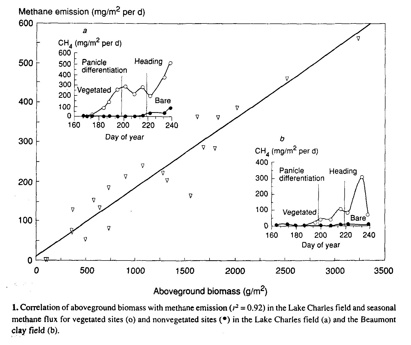
Methane emission (flux) and above and below-ground biomass were measured at four random locations in each field. Integrated annual methane emissions ranged from 4.5 (Beaumont Clay) to 15.9 (Lake Charles) g/m2 per season (determined by static flux box measurements) .
Methane emission was detected from vegetated plots shortly after flooding in the Lake Charles field and was strongly related to aboveground biomass throughout the growing season (Fig. 1). Virtually no methane flux could be detected in nonvegetated plots until late in the season (Fig. 1, insert a).
No significant emission was observed in vegetated plots in the Beaumont Clay field until panicle differentiation. This delay may have been caused by the field drainage and soil aeration that resulted from levee damage (Fig. 1, day 177, insert b). The effect of field drainage and intense rainfall on exposed soils will be further examined as weather conditions permit.
Methane production, measured in laboratory-incubated soil core segments from both fields, was spatially and temporally related to live root biomass (Fig. 2). Early methane production was highest in the 0-2.5 cm soil layer associated with the dense fibrous root system near the soil surface and lowest in the 7.510 cm depth and between plant rows.
As the growing season progressed, methane production at lower depths and farther away from the plants increased in proportion with root density. Seasonal integrated emission in the laboratory was 42% that of the methane production measured by static flux boxes in both fields.