 Reproduced with permissions
Diana M. Liverman[1]
The crop-modeling work discussed in this paper will contribute to the U.S. Environmental Protection Agency (EPA) study on the international agricultural impacts of climate change. The EPA study uses GCM output to project the impact of changes in climate on crop yields at sites in 22 countries by using the crop models of the International Benchmark Sites Network for Agrotechnology Transfer (IBSNAT).
GCM runs with doubled CO2 (2xCO2) indicate significant increases in temperature and changes in precipitation in Mexico. Mexico is the 13th largest contributor to global greenhouse gases, producing 1.4% of the total net emissions (World Resources Institute, 1990). For Mexico, continually striving to support a growing population with an agricultural system that relies on relatively low and variable rainfall, any warmer, drier conditions could bring nutritional and economic disaster. More than one-third of Mexico's rapidly growing population works in agriculture, a sector whose prosperity is critical to the nation's debt-burdened economy. Although only one-fifth of Mexico's cropland is irrigated, this area accounts for half the value of the country's agricultural production, including many export crops. Many irrigation districts rely on small reservoirs or wells, which deplete rapidly in dry years. The remaining rain-red cropland supports many subsistence farmers and provides much of the domestic food supply. Frequent droughts already reduce harvests and increase hunger and poverty in much of Mexico (Liverman, 1990).
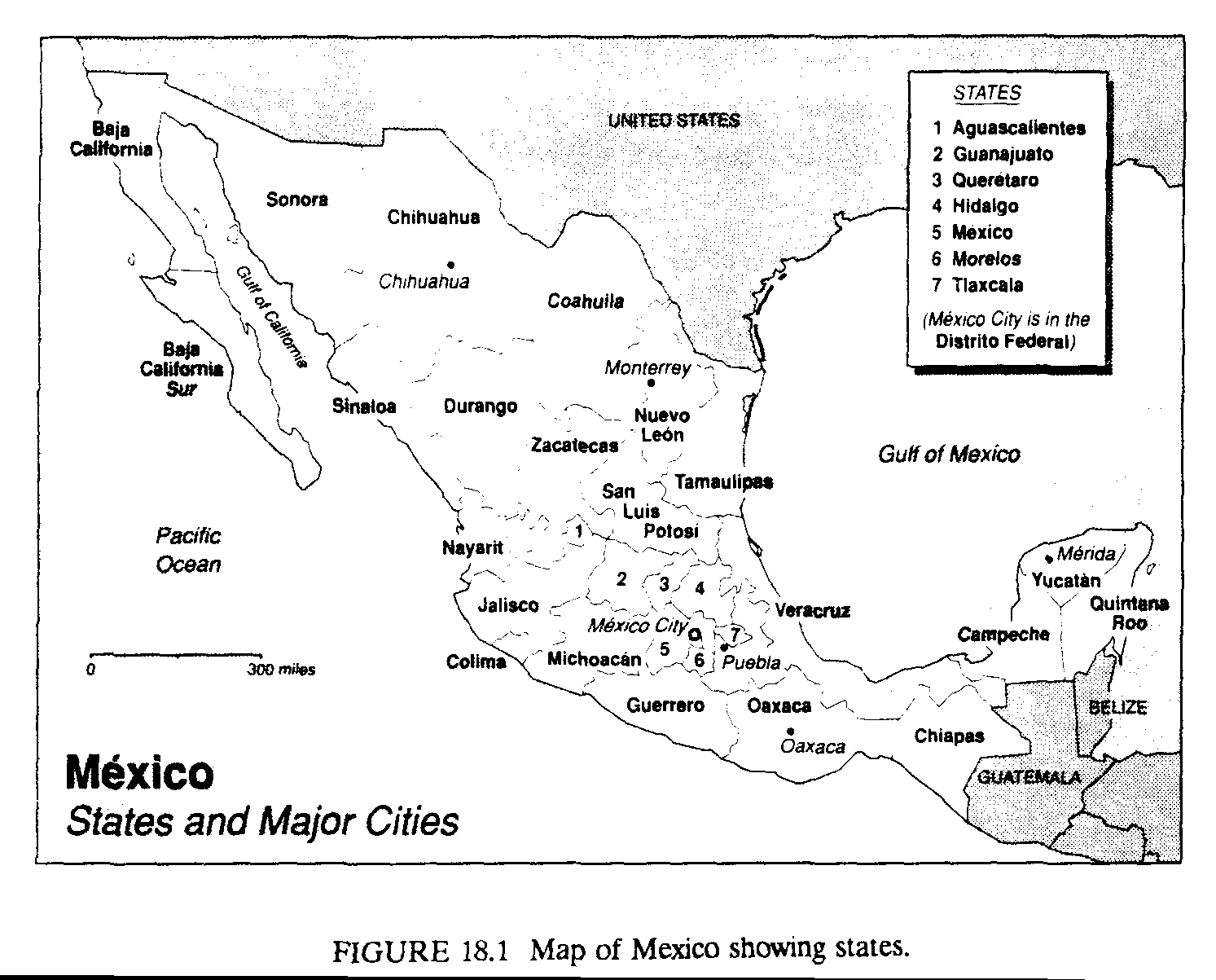
There is a significant geographic mismatch between water and population in Mexico (Enge and Whiteford, 1989). Seven percent of the land, lying in the extreme southeast of the country (states such as Veracruz and Tabasco), receives 40% of the rainfall (Figure 18.1). Only 12% of the nation's water is on the central plateau (states such as Puebla, Mexico, and Guanajuato), where 60% of the population and 51% of the cropland are located. In arid northwest Mexico (Sonora and Sinaloa), much of the agriculture depends on irrigation development. Water-supply infrastructure has tended to lag behind rapid urban and industrial development in regions around Mexico City and along the U.S. border. Cities, industry, and hydroelectric power compete with agriculture, which consumes more than 80% of total water supplies.
How might global warming alter climate conditions in different parts of Mexico? Mexico lies between latitudes 15deg. and 32deg. north, with a climate influenced by three seasonally shifting features of the general circulation: the westerly winds, which bring winter rain to the extreme northwest of Mexico; the subtropical high-pressure belt, which brings stable, dry conditions to most of the country in winter and to the north in summer; and the intertropical convergence zone and trade winds, which bring substantial rains as they move north in the summer. In winter, cold polar air can surge southward over Mexico in "nortes," bringing rain and damaging frost. In midsummer, high pressure sometimes develops over the central plateau with a disruption of easterly flow, bringing a period of drought conditions called the "canicula" (Garcia, 1965; Metcalfe, 1987; Mosino, 1975).
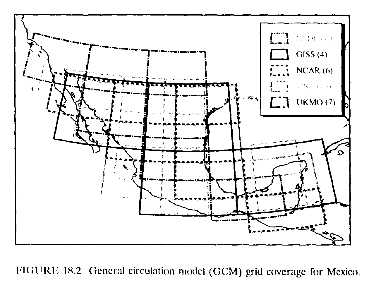
We have obtained results from five major GCMs for the grid squares covering Mexico. The models are as follows:
The models vary in their assumptions about clouds, ice feedbacks, and oceans and in their characterization of topography, geography, and soil depth, among other factors. Despite these differences, there are many similarities in the models' structures and the ways complex processes are represented by statistical relationships (i.e., parameterizations). The model characteristics and results have been compared by Bach et al. (1985), Schlesinger and Mitchell (1987), and Jenne (unpublished observations).
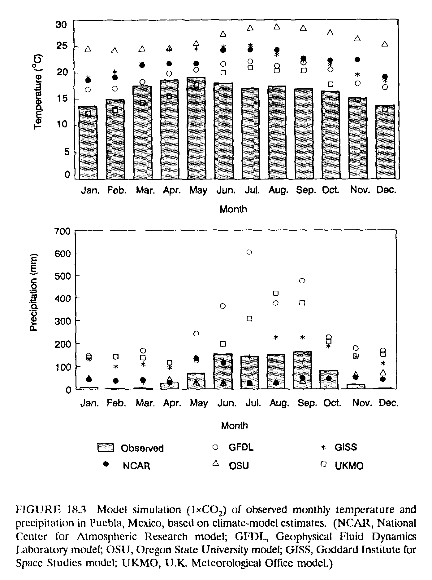
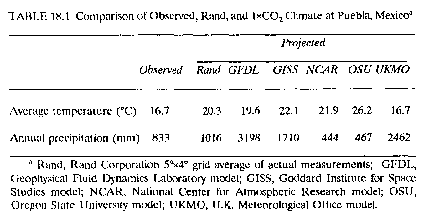
All models, except for the UKMO model, overestimate temperatures at Puebla--by almost 10deg.C in the case of the OSU model. This error probably results from the lack of topographical detail in the models, because Puebla's cooler observed temperatures result from its 2166-m altitude. The UKMO model may have more accurate temperatures because it sets the Puebla grid square at 1351 m, whereas the Goddard and GFDL models have much lower elevations at 785 m and 616 m, respectively, with correspondingly warmer temperatures. For rainfall, the NCAR and OSU models only produce about half the observed annual amount at Puebla, whereas the other models overestimate rainfall by as much as four times. Monthly comparisons are shown in Figure 18.3.
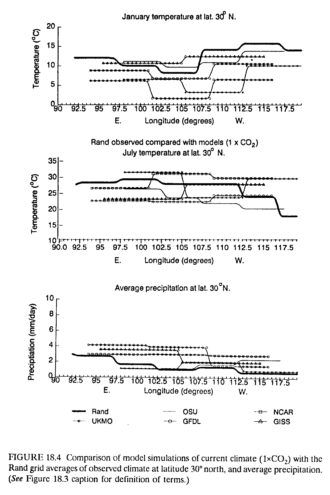
Individual meteorological-station conditions may not be representative of the regional climates that correspond to the scale of the GCM grids. The heterogeneity of the Mexican environment means that meteorological observations within a model grid square may vary widely. To investigate this, we use regional averages or observed climates developed by the Rand Corporation (Santa Monica, Calif.), in which temperature and precipitation are averaged for meteorological stations within a 5deg.-by-4deg. geographic grid. As can be seen from Table 18.1, the Rand conditions are a little wetter and slightly warmer than the individual station value at Puebla. Figure 18.4 shows model results compared with Rand climatology for January and July temperatures and annual precipitation, across an cast-west transect at latitude 30deg. north. Observed conditions in January show a general increase in temperatures from east to west, but with a decline around 105deg. west longitude, which represents The cooling influence or higher-elevation stations. The NCAR and OSU models most closely follow this climatology; the UKMO and GEDL models produce temperatures that are too low, even in the highland region. The Rand annual rainfall declines from east to west across northern Mexico, from the more humid Gulf Coast to the deserts along the Pacific. There is a slight increase in observed rainfall as air starts to rise over the highlands at longitude 110deg. west. The Goddard and GFDL models show rainfall decreasing from east to west, but the OSU model produces an opposite trend. The UKMO model seems to best replicate the orographic rainfall increase over north-central Mexico.
These results demonstrate some of the inadequacies in the ability of climate models to reproduce observed climates and can lead to distrust of the changes projected by the models, particularly for precipitation. Further caution in using model results for climate-impact studies is indicated in the chapter on climate variability in a recent EPA report (U.S. EPA, 1989), which suggests that the models are unable to reproduce the variability of observed climate.
Thus, the temperature change is calculated by subtracting the 1xCO2 from the 2xCO2 temperatures for each grid square. For rainfall, especially in an arid region, the absolute change in precipitation from 1xCO2 to 2xCO2 runs is sometimes much greater than the total observed rainfall. In these cases, use of the absolute change could give an unrealistically high, or even below-zero, rainfall. Many researchers have therefore used the ratio, or percentage, method to estimate precipitation changes (Parry et al., 1988; Adams et al., 1990).
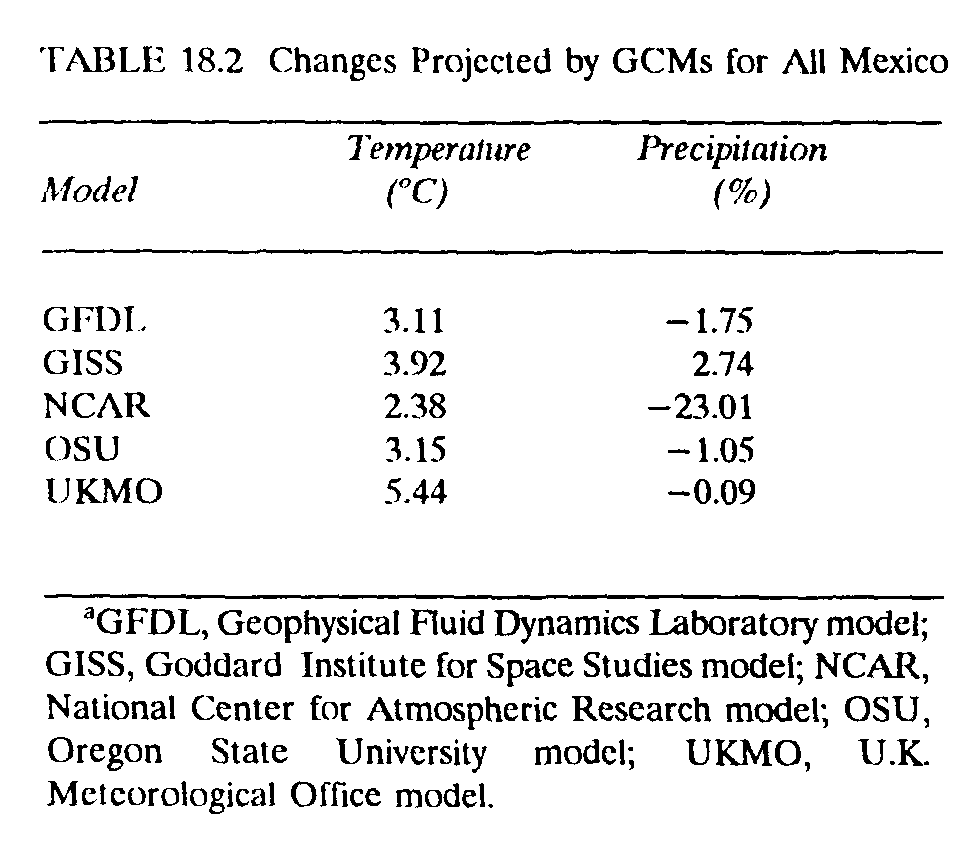
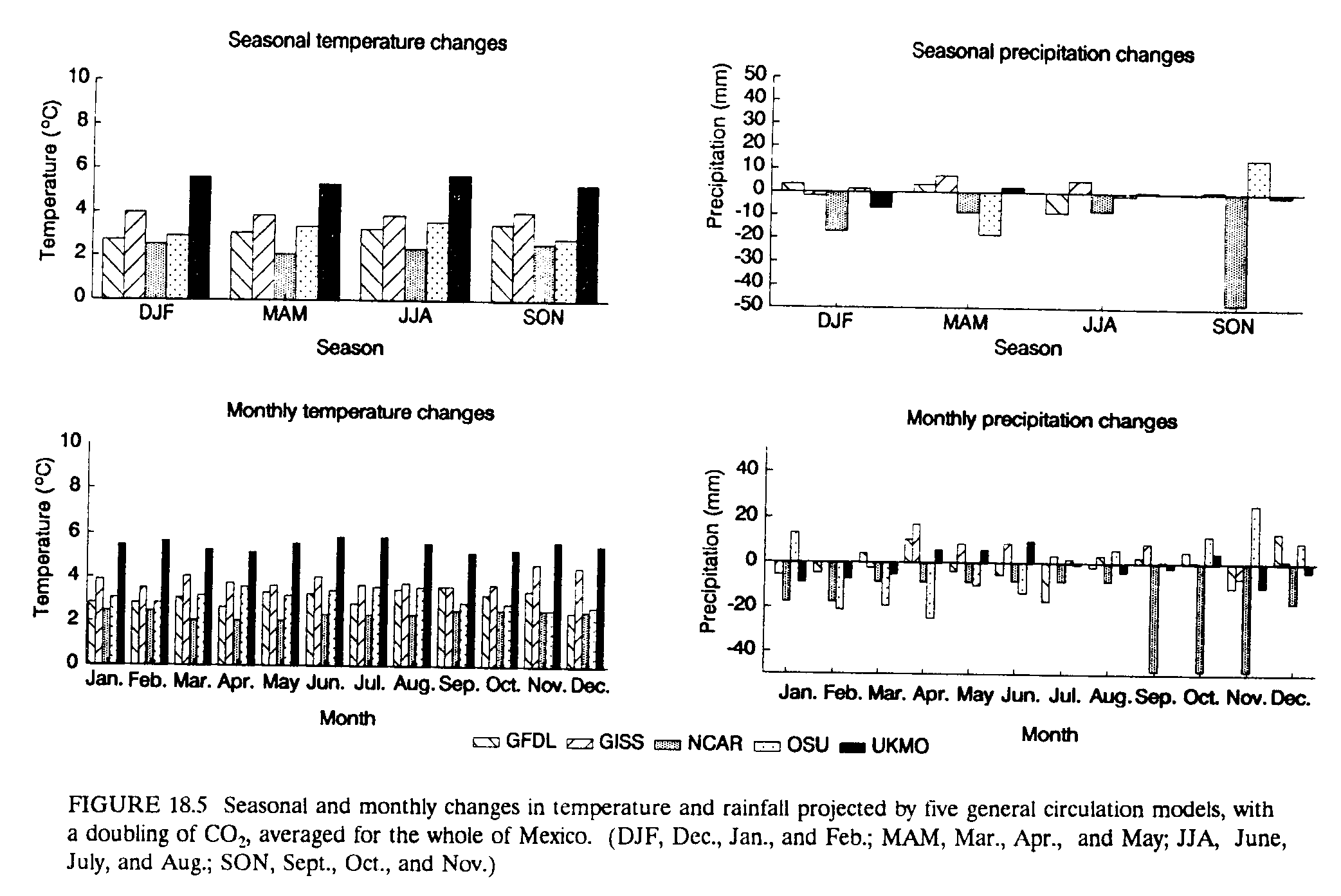
What changes do the models project for Mexico, and do these projections show any agreement? Recall that the models each have a different number or grid squares covering Mexico (Figure 18.2). Averaging the changes projected by each model for the whole of Mexico gives a general sense of the similarities and differences between them. The UKMO model forecasts the greatest regional temperature increase, 5.44 deg.C, and the NCAR model the least, 2.38 deg.C (Table 18.2). The NCAR model predicts a 23% decrease in rainfall, and the GISS model, a 3% increase. The size and, in the case of rainfall, the direction of change, varies depending on the spatial and temporal scale of analysis. When we look at average changes for the whole of Mexico but seasonally and monthly rather than annually, we see much greater differences between the models (Figure 18.5). For example, we find that the OSU model has its greatest temperature increases in the summer, whereas the GISS and NCAR models have their greatest increases in the fall and winter. The differences between the model predictions for precipitation are very dramatic seasonally. For example, in the NCAR model, fall rainfall decreases by almost 50% with doubled CO2, and that for the OSU model increases by 15%. Monthly comparisons show even more extreme differences in the size and direction of projected changes.
We chose to use the monthly results for individual grid squares to investigate climate change in Mexico. This choice highlights the differences between the models and maximizes the representation of seasonal variability. Daily data, not available for this study, would permit an even better examination and representation of variability within and between the models. We also chose to use the results from all five models in generating climate-change scenarios for Mexico to capture some of the uncertainties in the projections for global warming.
The most common approach to analyzing the regional impacts of global warming is to take the type of changes estimated by the models, as discussed above, and modify current climates to represent doubled-CO2 conditions. Temperature changes are added or subtracted from observed conditions, and observed precipitation is multiplied by the estimated percentage change.
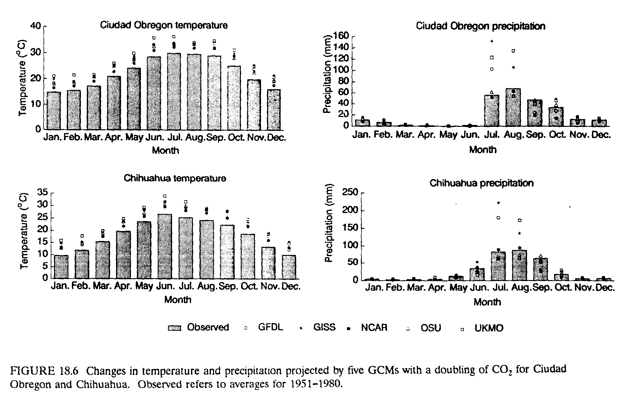
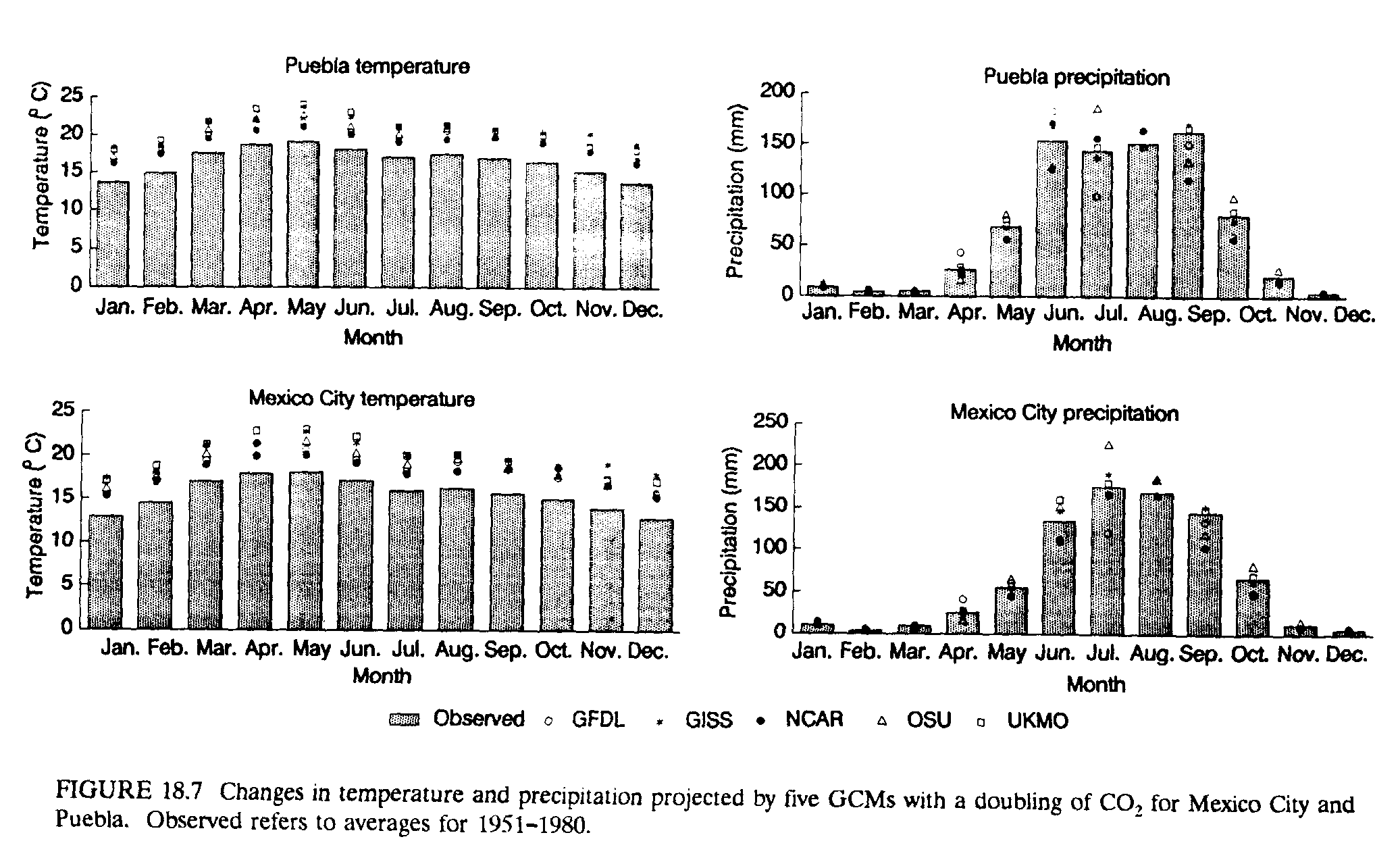
Figures 18.6 and 18.7 show how climate may change at some meteorological stations in Mexico. At all stations, all of the models project increases in temperature in every month of the year, resulting in more months of extremely high summer temperatures. For example, mean monthly temperatures of ~25 deg.C in Chihuahua could increase to almost 30 deg.C, with some models predicting at least 1 month above 35 deg.C. In Ciudad Obregon, which already experiences summer temperatures near 30 deg.C, several months could approach 35 deg.C. These temperature increases in the already hot summers of northern Mexico are likely to bring great stress to humans, plants, and animals, especially if these monthly averages imply even higher daily extremes. On the other hand, warmer temperatures may extend the growing season in areas at higher elevations, such as Chihuahua, which sometimes has cold temperatures and frosts in winter months. In Ciudad Obregon, located in one of the most important irrigated agricultural regions of Mexico, the GISS and UKMO models indicate that rainfall may increase in July and August, whereas other models bring lower rainfall throughout the year. Chihuahua's climate scenarios follow a similar pattern, but with distinct drops in OSU and GFDL estimates for summer rainfall.
In central Mexico, temperature increases are not quite as high as in the north. For example, Mexico City's current winter temperatures of ~12 deg.C could increase to as high as 18deg.C. Warmer temperatures could reduce frost risks in the highland agricultural regions around Mexico City and Puebla.
Information obtained for the water balance of the GISS and OSU models suggests that potential evaporation will increase in all months because higher air temperatures increase the atmospheric demand for moisture in air that is relatively dry. The GISS model internally estimates a 15% increase in potential evaporation for the Chihuahua grid square and a 2% increase in Puebla. The OSU model projects a 12% decrease in potential evaporation at Chihuahua and a 6% increase in Puebla.
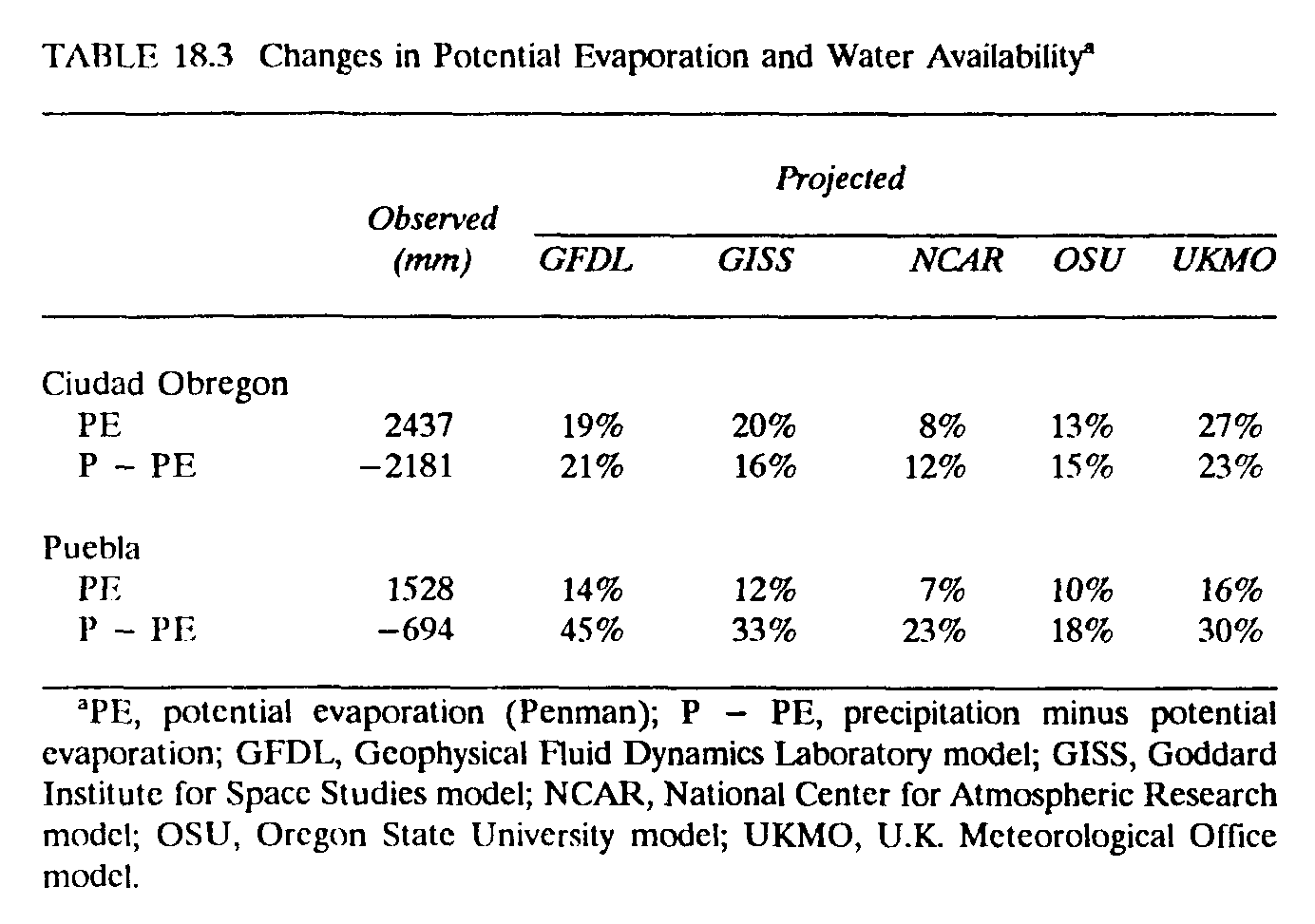
Because of the limitations of modeling soil moisture, we have also used model projections of precipitation, temperature, and solar-radiation changes to estimate exogenous evaporation and moisture availability by the Thornthwaite and Penman methods.[2] Table 18.3 shows the exogenously estimated changes in Penman potential evaporation for the stations of Puebla in central Mexico and Ciudad Obregon in the northwest irrigated region. Current Penman potential evaporation totals ~1528 mm/year under current (1951-1980) climate in Puebla. With global warming, this could increase from 7% to 16%, depending on the climate model. These results have serious implications for water resources and irrigation in central Mexico, because they imply increased losses from open water surfaces such as reservoirs. In Ciudad Obregon, current potential evaporation in this desert-like environment is 2438 mm/year. The higher temperatures associated with global warming could increase this evaporation 8-27%.
The relationship between increased potential evaporation and changes in rainfall can be approximated over a year by subtracting total annual potential evaporation from annual rainfall to produce an estimate of moisture surplus or deficit. Under current climate, such a calculation for Puebla produces a moisture deficit of 694 mm. That is, potential evaporation is about double precipitation. Global warming could increase this deficit 17-45%, depending on the climate model. A 45% moisture deficit would occur with the GFDL scenario, because this model combines a temperature increase and a large precipitation decrease at Puebla. Although the UKMO model projects the largest potential evaporation increase for Puebla, an increase in precipitation partly offsets this, for a deficit increase of 30%. Similar scenarios occur in the northwest, with moisture deficits increasing in Ciudad Obregon between 15% and 23%. This reduction in water availability would harm both rain-fed and irrigated agriculture in the region. The implications of possible errors in the model projections for precipitation and solar radiation have been investigated through a sensitivity analysis of the Penman calculations. For example, we find that it would require significant decreases in wind speeds (-50%) or solar radiation (-20%) to prevent an increase in potential evaporation with higher temperatures. Moisture deficits could only be reduced by much larger increases in rainfall than currently projected by the models. Only if the climate models are greatly overestimating temperature increases, or if they are very wrong about rainfall and solar radiation, does the future seem optimistic for water availability if global warming occurs in Mexico.
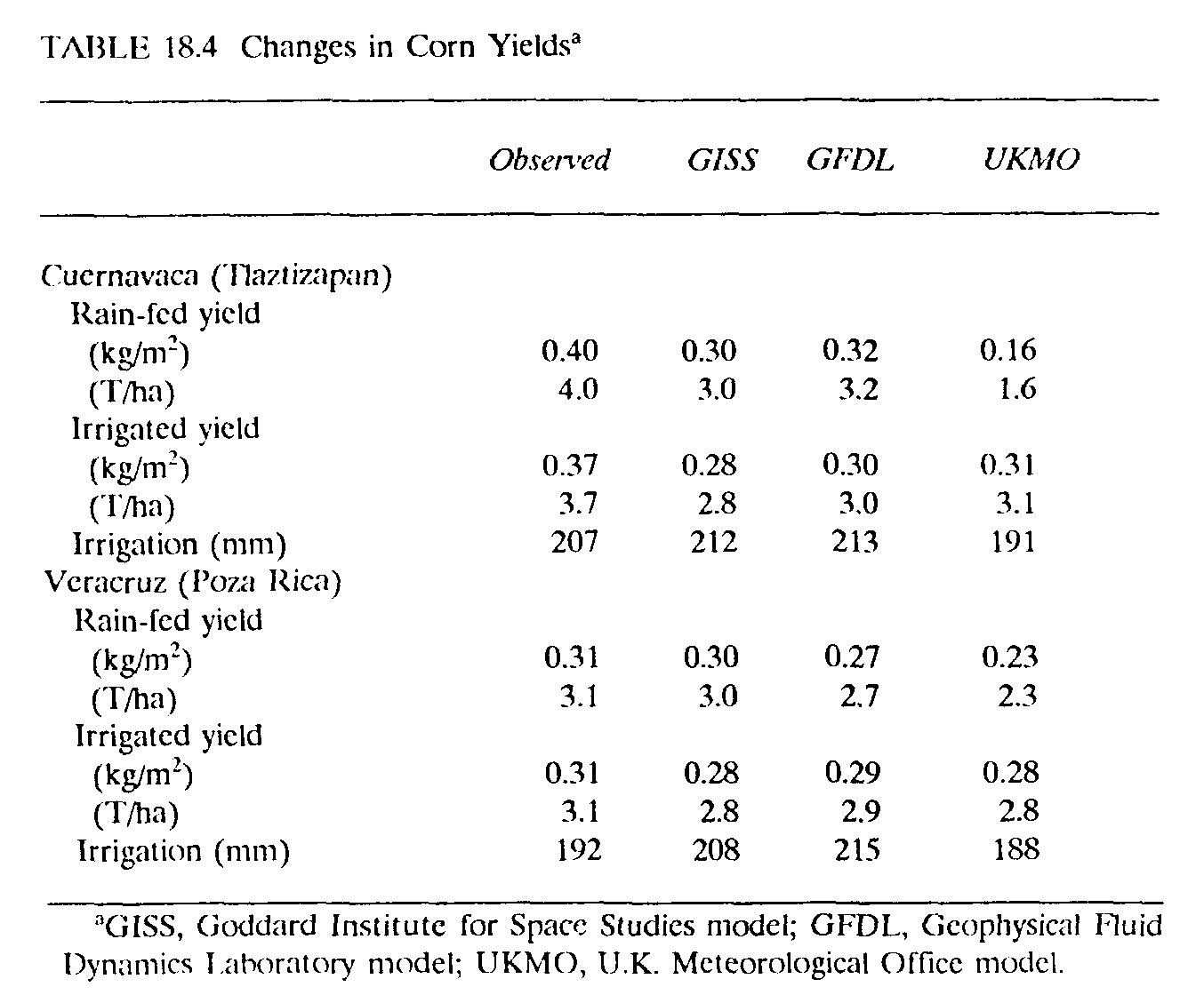
Yields of corn, the major staple in Mexico, have been simulated at several sites in Mexico. The CERES model has been validated for sites near Cuernavaca (in a highland valley south of Mexico City) and Veracruz (on the Gulf Coast) with agricultural experiment data provided by the International Center for Wheat and Maize Improvement (CIMMY I). The model has been run with observed weather data to simulate rain-fed and irrigated yields of corn under typical soil and management conditions. In rural Mexico, corn is typically grown by poorer farmers who cannot afford chemical fertilizers. Thus, we use only 50 kg of nitrogen fertilizer at planting in the model runs, and assume soils of relatively low fertility and moisture content. The planting density is three plants per square meter.
Climate-change scenarios are generated with results of the GFDL, GISS, and UKMO climate models for likely changes in temperature, precipitation, and solar radiation with a doubling of CO2. Rain-fed and irrigated yields are then simulated under these changed climates with higher concentrations of CO2 (555 umol/mol, or 555 ppm) and compared with the yields estimated for the years of observed weather. The results of these experiments, which initially assumed no alterations in planting dates or other input conditions as the climate changed, are shown in Table 18.4.
At the Cuernavaca site, average yields of rain-fed corn for the 1974-1989 period are estimated at 0.40 kg/m2 [4.0 tons/hectare (T/ha)]. All rain-fed climate-change scenarios result in drops in corn yields at Cuernavaca, ranging from a 20% drop for the GFDL model to a 60% drop for the UKMO model. Under observed conditions, only one year, 1989, produces yields below 0.1 kg/m2 (1 T/ha). The GISS and UKMO models increase this frequency to 7 years, and GFDL, to 2 years. These low yields occur despite overall rainfall increases projected by some models, because higher temperatures create elevated evaporation early in the growing seasons, and in some cases high rainfall leaches nutrients out of the soil.
Irrigated yields for 1974-1989 at Cuernavaca average 0.37 kg/m2 (3.7 T/ha), with 207 mm of irrigation water applied during the growing season. Irrigated yields do not drop as much under changed climates, ranging from a drop of l6% in the UKMO case to 24% in the GISS case. Irrigated scenarios for global warming produce less-variable yields, but do not exceed, on average, the current yields. Demand for irrigation water increases by ~3% compared with current climate, except for the UKMO scenario, in which the demand decreases. Projections for moisture deficits at Puebla, ~150 km (~100 miles) from Cuernavaca, indicated by the Penman calculations above, suggest that this extra irrigation water may not be available in a warmer climate.
Recent (1973-1979) rain-fed yields of corn at the site near Veracruz average 0.31 kg/m2 (3.1 T/ha) and decrease 13% with the GFDL model, 26% with the UKMO model, and 3% with the GISS model. Irrigated yields currently average 0.31 kg/m2 (3.1 T/ha), only decreasing by 10% for the GISS and UKMO models, and 6% for the GFDL model. Irrigation needs increase by 2-12%, depending on the model.
These yield declines and crop failures projected for corn, a crop important to Mexico's food self-sufficiency and for peasant livelihoods, are extremely serious. However, sensitivity analyses indicate the importance of some of the current uncertainties in estimating the impacts of future climatic changes. The results reported above assume no change in the average date of planting, with crops planted on May 20 (Cuernavaca) and June 20 (Veracruz) in both observed and GCM conditions. These are average planting dates under current climate, which allows farmers to balance the risk of late spring rains and early fall frosts. We are currently investigating whether earlier and later sowing dates may offset the negative impacts of a warmer climate. We have also left the crop variety unchanged in these initial experiments and will be seeing if different varieties may adapt better to global warming. It is also possible to design hypothetical genetic coefficients within the CERES model that maintain high yields under global warming, but it is not clear that these coefficients are biologically possible. The sensitivity of the model results to these factors will indicate possibilities for adjusting to global warming through altering the dates of planting and the genetic type or characteristics of the seed.
The amount of fertilizer and irrigation is critically important to the corn yields predicted by the CERES models. The experiments above all assume relatively low fertilizer use because many Mexican producers can only afford to use 50-100 kg of nitrogen fertilizer at planting. If more fertilizer becomes available to more farmers as the climate changes, then some of the yield reductions might be offset. Only with adequate water and fertilization can the direct effects of CO2 be of significant advantage to C3 plants such as corn. When we run observed and model scenarios with no water or nutrient limitations, we find that the GISS scenario produces 0.39 kg/m2 (3.9 T/ha) in Cuernavaca [compared with 0.28 kg/m2 (2.8 T/ha) with nutrient-limited, irrigated observed climate], the GFDL model, 0.40 kg/m2 (4.0 T/ha), and the UKMO model, 0.39 kg/m[2] (3.9 T/ha). However, given the environmental and economic constraints and trends in agricultural inputs in Mexico, unlimited water and nutrients are extremely unlikely. The experiment illustrates, however, the sensitivity of corn yields to assumptions about future resource availability.
For export-oriented agriculture and price incentives to producers, it will be Mexico's comparative advantages and disadvantages in agricultural production in a warmer world that may determine the national and regional economic impacts of climate changes. We have not yet undertaken any detailed estimates on other crops or the areas of land that may be threatened by sea-level rises. Many low-lying coastal agricultural areas in Mexico would be threatened by sea-level rises. In some cases, the threat might be of direct flooding of land or of increased storm damages (e.g., along the Gulf Coast), but in others, such as Sonora and Sinaloa, the threat would be to irrigation systems and soil fertility through rising water tables and salinization.
Again, despite differences between the climate-model results, the general direction of changes in Mexican corn yields with global warming is a decrease, whatever the model, and whether irrigation is used or not. Sensitivity analysis indicates that decreases in crop yields will be severe under global warming unless irrigation expands, fertilizer use increases, or new varieties are developed.
2 These methods are discussed in Rosenberg (1974).
Bach W., H. J. Jung, and H. Knottenburg. 1985. Modeling the Influence of Carbon Dioxide on the Global and Regional Climate: Methodology and Results. Paderborn, Germany: Ferdinand Schoeningh.
Cohen, S. J. 1986. "Impacts of CO2-Induced Climatic Change on Water Resources in the Great Lakes Basin." Climatic Change 8: 135-53.
Enge, K. I., and S. Whiteford. 1989. The Keepers of Water and Earth: Mexican Rural Social Organization and Irrigation, Austin: University of Texas Press.
Garcia, E. de Miranda. 1965. Distribucion de Precipitacion en la Republica Mexicana. Mexico, D.F.: Instituto de Geografia de Universidad Nacional Autonoma Mexicana (UNAM).
Gleick, P. H. 1988. "The Effects of Future Climatic Changes on International Water Resources: The Colorado River, the United States, and Mexico." Policy Sciences 21: 23-39.
Gleick, P. H. 1989. "Climate Change and International Politics: Problems Facing Developing Countries." Ambio 18(6): 333-9.
Hansen, J., G. Russell, D. Rind et al. 1983. "Efficient Three-Dimensional Global Models for Climatic Studies: Models I and 11." Monthly Weather Review 3(4): 609-62.
Jenne, R. Unpublished notes. "Data from Climate Models." Boulder, Colo.: National Center for Atmospheric Research.
Jodha, N. S. 1989. "Potential Strategies for Adapting to Greenhouse Warming: Perspectives from the Developing World," in N. Rosenberg, W. E. Easterling, and P. Crosson, eds., Greenhouse Warming: Abatement or Adaptation. Pp. 147-58. Washington, D.C.: Resources for the Future.
Jones, C. A., and J. R. Kiniry. 1986. CERES-Maize: A Simulation Model of Maize Growth and Development. College Station: Texas A&M Press.
Kellogg, W. W., and Z. Zhao. 1988. "Sensitivity of Soil Moisture to Doubling of Carbon Dioxide in Climate Experiments. Part 1: North America." Journal of Climate 1: 348-66.
Liverman, D. M. 1990. "Vulnerability to Drought in Mexico: The Cases of Sonora and Puebla in 1970." Annals of the Association of American Geographers 80(1): 49-72.
Manabe, S., and R. T. Wetherald. 1987. "Large Scale Changes in Soil Wetness Induced by an Increase in Atmospheric Carbon Dioxide." Journal of the Atmospheric Sciences 44: 1211-35.
Meehl, G. A., and W. M. Washington. 1988. "A Comparison of Soil Moisture Sensitivity in Two Global Climate Models." Journal of the Atmospheric Sciences 45(9): 1476-92.
Metcalfe, S. E. 1987. "Historical Data and Climate Change in Mexico: A Review." The Geographical Journal 153(2): 211-22.
Mosino, P. A. 1975. "Los Climas de la Republica Mexicana," in Z. Cserna, ed., El Escenario Geografico. Pp. 57-171. Mexico, D.F.: Instituto de Geografica de Universidad Nacional Autonoma Mexicana (UNAM).
Parry, M. L., T. R. Carter, and N. T. Konjin, eds. 1988. The Impact of Climatic Variations on Agriculture. Volumes I and 2. Dordrecht, The Netherlands: Kluwer.
Rosenberg, N. 1971. Microclimate: The Biological Environment. New York: John Wiley & Sons.
Schlesinger, M. E., and J. F. B. Mitchell. 1987. "Model Projections of the Equilibrium Response to Increased Carbon Dioxide." Review of Geophysics 25: 760-98.
Schlesinger, M. E., and Z. Zhao. 1989. "Seasonal Climatic Changes Induced by Doubled CO2 as Simulated by the OSU Atmospheric GCM/Mixed-Layer Ocean Model." Journal of Climate 2: 459-95.
U.S. Environmental Protection Agency (U.S. EPA). 1989. The Potential Effects of Global Climate Change on the United States. Washington, D.C.: U.S. EPA.
Washington, W. M., and G. A. Meehl. 1986. "Climate Sensitivity Due to Increased CO2: Experiments with a Coupled Atmosphere and Ocean GCM." Climate Dynamics 4: 1-38.
Wilson, C. A., and J. F. B. Mitchell. 1987. "A Doubled CO2 Climate Sensitivity Experiment with a Global Climate Model Including a Simple Ocean." Journal of Geophysical Research 92(D11): 13315-43.
World Resources Institute. 1990. World Resources 1990-91. Oxford, England: Oxford University Press.