|
|
New Study Addresses Growing Threat of Extreme Heat in Cities Worldwide
|
|
October 4, 2021
|
|
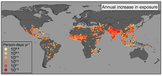
Source: Tuholske et al., PNAS, 2021
Annual municipality-level increases in the rate of urban population exposure to extreme heat, 1983–2016. |
Rising air temperatures associated with climate change are a threat to cities throughout the world, but especially to the urban poor. The poor generally have fewer adaptive resources and less protective shelter; they have greater health vulnerability to extreme heat, and lower ability to evacuate. These conditions can be exacerbated by the urban heat island effect, where closely spaced structures with lots of pavement and limited green space, common to poorer neighborhoods worldwide, retain heat more readily and for a longer duration. Better understanding of patterns of local exposure to extreme heat is critically needed to design adaptive measures and improve health outcomes. However, until now, global, fine-resolution data on the intersection of extreme heat and population distribution in urban settings have been limited. A new study published in the prestigious journal, Proceedings of the National Academy of Sciences (PNAS), “Global Urban Population Exposure to Extreme Heat,” is the first to combine temperature, relative humidity, and population data to provide a more detailed and comprehensive view of how extreme heat exposure is likely to impact many more people in cities around the world in the coming decades. Lead author is Earth Institute Fellow Cascade Tuholske, based at CIESIN, with co-authors Kelly Caylor, Chris Funk, Andrew Verdin, Stuart Sweeney, Kathryn Grace, Pete Peterson, and Tom Evans. The team used new, fine-resolution temperature, relative humidity, and population data to assess urban extreme heat exposure in more than thirteen thousand cities, from 1983 to 2016. Using a daily maximum wet bulb globe temperature threshold of 30°C (86°F)—which accounts for a combined impact of both temperature and humidity on human health and wellbeing—global exposure was seen to increase nearly 200% from 1983 to 2016. Total urban warming elevated the annual increase in exposure by approximately 50% compared to urban population growth alone. Exposure increased for nearly half of urban settlements worldwide, which in 2016 comprised 1.7 billion people. The authors also found that how total urban warming and population growth drove the trajectory of exposures was not evenly distributed, thus reinforcing the importance of crafting adaptation measures that address local needs. Their findings further suggest that previous research has underestimated extreme heat exposure, underscoring the necessity for improved data to support the development of targeted adaptions such as early warning systems to reduce harmful effects, especially on the urban poor. Visualize the Data/Associated Press
See: “Global Urban Population Exposure to Extreme Heat” (PNAS paper)
“Exposure to Deadly Urban Heat Worldwide Has Tripled in Recent Decades, Says Study” (blog)
Global High Resolution Daily Extreme Urban Heat Exposure (UHE-Daily) Data Set
|
|
Data Set Enables Finer View of U.S. Social Vulnerability to Disasters
|
|
August 31, 2021
|
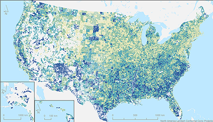
This summer has seen a spate of extreme climate-related events, from record high temperatures to forest fires, floods, and severe storms. Climate and other natural and manmade hazards do not affect all populations equally. Some sub-populations are particularly vulnerable to their effects owing to factors such as low income, lower levels of education, poor housing, or historical inequalities. Parsing out the fine-grained layers of social conditions across the strata of society—how much money people make, who makes up their households, minority status, ability to understand English, dwelling places, and access to transport—can provide the fundamental elements needed to quantify social vulnerability to hazards in the United States. The Centers for Disease Control (CDC) Social Vulnerability Index (SVI), created by the Geospatial Research, Analysis, and Services Program (GRASP) of the Centers for Disease Control and Prevention (CDC) and the Agency for Toxic Substances and Disease Registry (ATSDR), has long been a key resource for local officials to identify communities that may need support before, during, or after hazardous events or disease outbreaks. To increase the utility of the SVI data set, the NASA Socioeconomic Data and Applications Center (SEDAC) operated by CIESIN gridded the input data and removed uninhabited areas. The resulting data set, the U.S. Social Vulnerability Index (SVI) Grids, enables calculation of the SVI for user-defined areas, facilitating integration with hazard and other geospatial data. The gridded SVI data set uses the same four themes as the CDC/ATSDR index—Socioeconomic, Household Composition and Disability, Minority Status and Language, and Housing Type and Transportation—to rank communities on vulnerability for the entire United States. The SVI data set is based on inputs at the census-tract level for 15 variables for the years 2000, 2010, 2014, 2016, and 2018, and aligns with the Gridded Population of the World (GPW) data set, SEDAC′s flagship data collection. A map gallery includes an overall SVI map and four maps visualizing each of the themes. Development of the gridded data set and maps was led by Carolynne Hultquist, post-doctoral research scientist at CIESIN.
See: U.S. Social Vulnerability Index Grids, v1 (2000, 2010, 2014, 2016, 2018)
|
|
CIESIN Staff, Collaborators, and Interns Present at KDD and AmeriGEO
|
|
August 27, 2021
For the AmeriGEO Week2021 held virtually August 23‒27, Cascade Tuholske, Earth Institute postdoctoral research scientist, gave a pre-recorded presentation, “Urban Extreme Heat Exposure Trajectories in AmeriGEO Countries.” Staff from CIESIN, the International Research Institute (IRI), and Lehman College, and graduate students from Lehman, presented and authored four poster papers. The students are interns working with postdoctoral research scientist Carolynne Hultquist, supported by the NASA Socioeconomic Data and Applications Center (SEDAC) operated by the Center. For the 2nd Knowledge Discovery and Data Mining (KDD) Workshop on Data-driven Humanitarian Mapping held virtually August 15, Lehman College student Lauren Carey gave a pre-recorded presentation on extracting street-level flood vulnerability data from Google Street View, based on a workshop paper co-authored with fellow students Raychell Velez, Christopher Aime, and Diana Calderon, together with staff from CIESIN, IRI, and Lehman College.
See: “Urban Extreme Heat Exposure Trajectories in AmeriGEO Countries” (presentation)
“Integrating Hazard Modeling, Exposure, and Vulnerability for Flash Flood Early Warning in Ecuador” (poster)
“Suitability of VIIRS Nighttime Lights (NTL) Satellite Data for Population and Migration Modeling in Oaxaca, Mexico” (poster)
“NASA SEDAC Data and Applications for Disaster Risk Reduction and Resilience, COVID-19” (poster)
“Advancing Data for Street-Level Flood Vulnerability: Extraction of Variables from Google Street View in Quito, Ecuador” (poster)
(paper)
|
|
‘Continuing’ Education at CIESIN, Despite Challenges
|
|
May 4, 2021
|
| Photo Credit: Anne-Laure White, GRID3 |
As face-to-face educational activities have been curtailed or even suspended due to the pandemic, CIESIN continues to be active on diverse educational fronts, in online and hybrid venues ranging from academic settings to video series to workshops and Webinars, in addition to ongoing development of online training and curriculum resources. CIESIN staff regularly teach popular courses at graduate and undergraduate level, in a variety of departments, programs, and schools across Columbia University, including Columbia and Barnard Colleges, the Ecology, Evolution, and Environmental Biology (E3B) Department, the Mailman School of Public Health, the School of International and Public Affairs (SIPA), and the School of Professional Studies (SPS). For the past Fall-Winter term, some CIESIN staff taught classes in “hyflex” mode (designated campus classroom, with online participation by students and faculty as needed)—for example, “Environmental Sustainability Indicators,” by associate director of Science Applications, Alex de Sherbinin, and “Data Analysis & Visualization in Sustainability,” by associate director for Geospatial Applications Greg Yetman. Both classes are in the Sustainability Management Program of the SPS. Supporting Yetman was postdoctoral research scientist Carolynne Hultquist, who taught the same class in the fall. Also this past semester, in online mode, GIS developer Kytt MacManus taught “Spatial Analysis for Sustainable Development,” and senior geographic information specialist Linda Pistolesi taught “GIS for Sustainable Development,” both for Columbia College. For E3B, research scientist Susana Adamo was instructor for “Human Populations and Sustainable Development.” CIESIN is also part of a major new initiative of the new Columbia Climate School. Led by Alex de Sherbinin and Kamal Amakrane, a United Nations diplomat and adjunct professor at SIPA, the Climate Mobility Network is one of nine new “Earth Networks” to facilitate interdisciplinary collaboration across Columbia University in the themes of climate, sustainability and the future of the planet. During its initial three-year phase, the Climate Mobility Network plans to develop a trans-disciplinary course, teaching aids, and tools to help build curriculum and pedagogy on climate mobility. The Network will also work on policy research and modeling in support of operational agencies, building on ongoing work with the World Bank, United Nations Development Programme, the Platform for Disaster Displacement, UNHCR-The UN Refugee Agency, and the International Organization of Migration, as well as the Columbia Global Centers Committee on Forced Migration. Online educational activities included an educational Webinar series for a non-technical audience, with modules to date on population modelling, mapping settlements, and mapping subnational boundaries, produced by the Georeferenced Infrastructure and Data for Development (GRID3) program. In a separate effort, several online training modules in English and Spanish were co-developed by Susana Adamo, with Professor Landy Sanchez of the Center for Demographic, Urban, and Environmental Studies at El Colegio de Mexico (COLMEX), released by the Population-Environment Research Network (PERN) and supported by the International Union for the Scientific Study of Population (IUSSP) through a grant from the William and Flora Hewlett Foundation. Focused on the fundamentals of spatial data integration and geared towards demographers and other population researchers, the video-based tutorials draw on pre-packaged data and open source geographic information system (GIS) and Web-based tools. This past year, CIESIN senior geographic information specialist Dara Mendeloff participated in Earth Institute Live (EI Live), an online series for K–12 students and educators. Coordinated by the Education and Outreach Office of the Lamont Doherty Earth Observatory (LDEO), live video lessons were led by experts in a broad variety of scientific disciplines across the EI. In one session, Mendeloff gave an introduction to geographic information systems (GIS); in another, she highlighted select data science tools used in climate research. She also took part in a professional development event for K–12 educators, sponsored by the EI, which focused on teaching climate change in the classroom.
See: Education and Resources at CIESIN
|
|
Virtual Venues Showcase Diverse Data Developments
|
|
April 27, 2021
CIESIN scientists remain active in a number of different scientific communities, despite travel restrictions due to the COVID-19 pandemic. On April 27, at the virtual meeting of the European Geophysical Union, Martin Juckes, co-manager of the Intergovernmental Panel on Climate Change (IPCC) Data Distribution Center (DDC), presented a lightning presentation and poster paper, “IPCC Data Distribution Centre: FAIR Data from Climate Research to Mitigation Policy.” Robert Chen and information scientist Xiaoshi Xing were co-authors. CIESIN is one of four organizations that jointly operate DDC; the other three are based in the UK, Germany, and Spain. The IPCC DDC provides access to key data sets used in IPCC assessments and reports. Also participating was Robert Downs, CIESIN senior digital archivist, who co-authored the presentation, “Towards Developing Community Guidelines for Sharing and Reusing Quality Information of Earth Science Datasets,” given by Carlo Lacagnina, Barcelona Supercomputing Centre. Senior digital archivist Robert Downs participated virtually in the Research Data Alliance (RDA) 17th Plenary Meeting (RDA P17) April 20–23 and the 16th International Digital Curation Conference (IDCC21) on April 19, both coordinated from Edinburgh, Scotland. During RDA P17, Downs presented the poster, “Peer Review of Open Research Data: The Approach of a Scientific Data Center.” He also chaired the joint session, “Collaborating to Improve Platforms and Share Resources among Open Data Repositories,” where he presented, “Improving Repositories through Collaboration.” At the IDCC21, Downs gave the presentation, “Documentation to Foster Sharing and Use of Open Earth Science Data: Quality Information,” co-authored with Ge Peng of NASA’s Marshall Space Flight Center, David Moroni of NASA’s Jet Propulsion Laboratory, Hampapuram Ramapriyan of Science Systems and Applications, Inc., and Yaxing Wei of Oak Ridge National Laboratory. As part of the International Research Institute for Climate and Society (IRI) seminar on April 20, CIESIN postdoctoral research scientist Carolynne Hultquist gave the presentation, “Bringing Vulnerable Populations into the Flood Risk Equation.” Two graduate student interns also participated: Raychell Velez, who is working toward her MS in geographic information systems (GIS) at Lehman College of the City University of New York; and Colleen Neely, an MPA student in environmental science and policy at Columbia’s School of International and Public Affairs (SIPA). Hultquist gave an overview of relevant data and services from the NASA Socioeconomic Data and Applications Center (SEDAC) and described ongoing efforts to improve vulnerability data for flood risk assessment. Velez presented work supported by SEDAC to develop high resolution data on building exposure to floods using artificial intelligence (AI) approaches. Neely, an Earth Institute intern with Hultquist and IRI scientist Andrew Kruczkiewicz, discussed work on a high resolution flood vulnerability index for Houston, Texas, designed to support more equitable flood mitigation efforts.
See: Research Data Alliance
16th International Digital Curation Conference
“Improving Repositories through Collaboration”
“Documentation to Foster Sharing and Use of Open Earth Science Data: Quality Information”
|
|
Where Does Big Data Fit in the Study of Migration Patterns?
|
|
April 23, 2021
CIESIN associate director for Science Applications Alex de Sherbinin teamed up with Prof. Andrew Tatem of the University of Southampton in the virtual event, “Using Big Data to Study Migration Patterns,” organized by the Columbia Population Research Center (CPRC) and Columbia’s Data Science Institute (DSI) on April 22. The two researchers discussed the use of novel data streams such as cellphone and device location data to understand mobility patterns. Following the presentation, which drew more than 50 participants, a reception was held for CPRC and DSI affiliates to discuss research collaboration opportunities. Among other activities, de Sherbinin is co-lead of the Climate Mobility Network, a new “Earth Network” established by the Earth Institute. Tatem is the director of WorldPop and a director of Flowminder, and a key collaborator in the GeoReferenced Infrastructure and Demographic Data for Development (GRID3) program managed by CIESIN.
See: “Mapping & Modeling Migration and Displacement with ‘Big’ Data”
|
|
New Air Quality and Gridded Scenario Data Released
|
|
April 9, 2021
CIESIN through its NASA Socioeconomic Data and Applications Center (SEDAC) has released two new data sets, one characterizing historical air quality over the period 1998–2016, and the second projecting urban land extent into the future through 2100 under different shared Socioeconomic Pathways (SSPs). The first data set, “Annual PM2.5 Concentrations for Countries and Urban Areas, 1998–2016,” provides annual mean estimates of levels of particulate matter (particles with diameters of 2.5 microns or less) in the atmosphere, derived from observations from satellite-based sensors, for countries and urban areas. The national averages are population-weighted. This data set is based on a gridded data set developed by van Donkelaar et al., also available from SEDAC. The data set “Global One-Eighth Degree Urban Land Extent Projection and Base Year Grids by SSP Scenarios, 2000–2100” was developed by Jing Gao of the University of Delaware and Brian O’Neill, now director of the Joint Global Change Research Institute at the University of Maryland. The data set characterizes global, spatially explicit urban land scenarios consistent with the SSPs, projected from the base year 2000 to the year 2100 at ten-year intervals, with a spatial resolution of one-eighth degree (7.5 arc-minutes). Such projections are key inputs for analyses of land use, energy use, and emissions and assessments of climate change vulnerability, impacts, and adaptation.
See: Annual PM2.5 Concentrations for Countries and Urban Areas, 1998–2016
Global One-Eighth Degree Urban Land Extent Projection and Base Year Grids by SSP Scenarios, v1 (2000 – 2100)
|
|
Spring Brings Staff Transitions
|
|
April 9, 2021
CIESIN is pleased to welcome Lixiang (Tracy) Wen as a finance manager, supporting the GeoReferenced Infrastructure and Demographic Data for Development (GRID3) program, the NASA Socioeconomic Data and Applications Center (SEDAC), and other projects. Tracy comes to CIESIN from the Columbia University Medical Center, where she worked as a financial analyst since 2016. She holds a bachelor of business administration in accounting from Baruch College. CIESIN bids farewell to Anne-Laure White, research staff assistant, who has begun working at a sustainable farm in the Hudson Valley. A graduate of Columbia University in American Studies, White had diverse roles in the Geospatial Applications Division over the past three years, including co-authoring a recent report on coastal adaptation.
|
|
Training in the Basics of Gridded Data and Applications for Addressing SDGs and Disaster Management
|
|
April 7, 2021
|
NASA’s Applied Remote Sensing Training Program (ARSET) offered a two-part training course, “Introduction to Population Grids and their Integration with Remote Sensing Data for Sustainable Development and Disaster Management,” on March 30 and April 6. The course was organized by CIESIN research scientist Susana Adamo on behalf of NASA’s Socioeconomic Data and Applications Center (SEDAC) and the POPGRID Data Collaborative, an international network of data providers, users, and sponsors concerned with georeferenced data on population, human settlements, and infrastructure. In the first session of the course, Prof. Steven Leyk of the University of Colorado and CIESIN associate director for Geospatial Applications Greg Yetman provided an overview of gridding population data, from its origins to present day applications in such areas as health, humanitarian response, sustainable development, and environmental management. The second session, organized around case studies of specific applications, featured lectures by CIESIN director Robert Chen, senior geographic information specialist Linda Pistolesi, and Charles Huyck, executive vice president of ImageCat Inc. More than 1,000 people from around the world participated in the course. Each session was given twice during the day, with live question-and-answer periods. Recordings of the sessions are available online via the ARSET web site.
See: Introduction to Population Grids and their Integration with Remote Sensing Data for Sustainable Development and Disaster Management—Register Here
|
|
Peter Fox,“Titan” in the Earth Science Informatics Community, Passes Away
|
|
April 2, 2021
CIESIN joins the broad earth science and informatics communities in mourning the sudden passing of Peter Fox, who was widely respected as a key scholar, thinker, and mentor across a wide range of interrelated fields. At Rensselaer Polytechnic Institute (RPI), Fox was Tetherless World Constellation Chair and director, Information Technology and Web Science Program, as well as professor of earth and environmental sciences, computer science, and cognitive science. He was a past president of the Federation of Earth Science Information Partners (ESIP), which, together with the American Geophysical Union (AGU), the Research Data Alliance (RDA), the Committee on Data (CODATA), and other organizations, characterized Fox as a “titan” in the Earth Science informatics community. Fox interacted regularly with many CIESIN staff members in different organizations, including ESIP, AGU, RDA, CODATA, and the International Science Council (ISC) World Data System (WDS). CIESIN director Robert Chen served with him on the ISC Strategic Coordinating Committee on Information and Data from 2009 to 2011, which helped guide the modernization and reorganization of the WDS. Fox was an active and valued member of the User Working Group (UWG) of the NASA Socioeconomic Data and Applications Center (SEDAC) operated by CIESIN, serving a four-year term from 2009 to 2013. He was a leading proponent of the value of interdisciplinary scientific data stewardship to advance science and societal benefits. Fox was especially known as a strong and supportive mentor for many different scholars and practitioners across a wide range of fields. Fox′s colleagues and friends at CIESIN, together with former and current members of the SEDAC UWG, are deeply saddened by this untimely loss and will greatly miss his wisdom, warmth, and wit. We extend our condolences to his family, friends, and colleagues around the world.
See: Peter Fox Obituary
|
|
Citizen Science Data Quality and Food Security Nexus are Topics of Recent Publications
|
|
March 30, 2021
A new article in Frontiers in Climate, “Perspectives on Citizen Science Data Quality,” offers a data lifecycle approach for improving data quality. Senior digital archivist Robert Downs is lead author, with co-authors Hampapuram Ramapriyan, Science Systems and Applications, Inc. (SSAI); Ge Peng, University of Alabama Huntsville; and Yaxing Wei, of the ORNL DAAC. CIESIN research scientist Susana Adamo and associate director for Science Applications Alex de de Sherbinin are among co-authors of the article, “Food Security among Dryland Pastoralists and Agropastoralists: The Climate, Land-use Change, and Population Dynamics Nexus,” appearing in The Anthropocene Review. Lead author is Illan Stavi, Ben-Gurion University of the Negev, Israel. Adamo is also one of the guest editors of the Special Issue of the Inter-American Institute for Global Change Research (IAI), “Bridging Science and Policy through Collaborative, Interdisciplinary Global Change Research in the Americas,” in the journal Environmental Development.
See: “Perspectives on Citizen Science Data Quality”
“Food Security among Dryland Pastoralists and Agropastoralists”
Special Issue: “Bridging Science and Policy through Collaborative, Interdisciplinary Global Change Research in the Americas”
|
|
Webinars Highlight Urban Population Data Applications and Data Management Topics
|
|
March 26, 2021
On March 25, CIESIN senior systems analyst/GIS developer Kytt MacManus moderated a Webinar organized by the Global Forum for Geography and Statistics (GFGS), the United Nations Economic Commission for Europe (UNECE), and the European Free Trade Association (EFTA), on the topics of defining urban areas and modelling urban area data. The first presentation was given by Lewis Dijkstra of the European Commission (EC) and former CIESIN research scientist Deborah Balk of Baruch College, and the second by Thomas Kemper and Marcello Schiavina of the EC Joint Research Centre. MacManus is a member of the GFGS steering committee. The fourth Webinar in a series designed for a non-technical audience has been produced by the Geo-Referenced Infrastructure and Demographic Data for Development (GRID3) managed by CIESIN. The Webinar, “Principles and Applications of Geographic Information Systems (GIS),” focuses on how GRID3 uses GIS tools and principles to inform its work, with an example from GRID3 activities with Ghana using GIS tools to support census modernization efforts there. Presenters include former CIESIN senior research staff assistant Anela Layugan; Frankline Echerue, technical specialist at the United Nations Population Fund (UNFPA); and Alina Game, GIS analyst at the Flowminder Foundation. Associate director for Science Applications Alex de Sherbinin gave welcoming remarks February 24 at session one of the Second Latin America and the Caribbean (LAC) Scientific Data Management Workshop. He then presented on the World Data System (WDS) of the International Science Council, for which he chairs the Scientific Committee. WDS convened the workshop in collaboration with the Brazilian Academy of Sciences, the São Paulo Research Foundation (FAPESP), and the Research Data Alliance (RDA). On February 19, senior digital archivist Robert Downs co-authored the lightning talk, “Toward Improving Representation of Data Quality Information,” which was presented by David Moroni of the NASA Jet Propulsion Lab (JPL) during the Earth Science Information Partners (ESIP) Winter Meeting Highlights Webinar.
See: Global Forum for Geography and Statistics Webinar
“Principles and Applications of Geographic Information Systems (GIS)” Webinar
|
|
New Data Released on Geocoded Hazards, Infant Mortality, and Shared Socioeconomic Pathways
|
|
March 22, 2021
The NASA Socioeconomic Data and Applications Center (SEDAC) operated by CIESIN has released several new data sets related to hazards, infant mortality, and future socioeconomic scenarios. The Geocoded Disasters (GDIS) Dataset is a geocoded extension of a selection of natural disasters from the Centre for Research on the Epidemiology of Disaster (CRED) Emergency Events Database (EM-DAT). The data set includes nearly 40,000 locations for almost 10,000 disasters worldwide for the 58-year period spanning 1960–2018. It encompasses all EM-DAT-recorded floods, storms, earthquakes, landslides, droughts, volcanic activity and extreme temperatures, some at administrative level 3 (district/commune/village) but most at 1 (typically state/province/region). GDIS facilitates geospatial analysis of past hazard events. The Shared Socioeconomic Pathways (SSPs) Literature Database consists of biographic information, abstracts, and analysis of 1,360 articles published 2014–2019 that make substantial use of the SSPs. The database was developed by Carole Green et al. as the basis for a recent article in Nature Climate Change that analyzes use of the Climate Change Scenario Framework and associated scenario data sets in diverse application areas and in assessments of the Intergovernmental Panel on Climate Change (IPCC). The International Committee on New Integrated Climate Change Assessment Scenarios (ICONICS) is planning to extend the literature database. SEDAC User Working Group member Brian O'Neill of the Joint Climate Change Research Institute and CIESIN director Robert Chen are members of ICONICS. Global Subnational Infant Mortality Rates (IMR), Version 2.01, provides more recent and higher-resolution infant mortality data, including estimates of births and infant deaths. The estimates are for 234 countries and territories, 143 of which include subnational units and are benchmarked to the year 2015 (versus year 2000 for the first version). IMR data are drawn from national offices, Demographic and Health Surveys (DHS), Multiple Indicator Cluster Surveys (MICS), and other sources covering 2006–2014. The birth and infant death data can be aggregated or disaggregated to calculate IMRs at different scales or resolutions. Boundary inputs are derived primarily from the Gridded Population of the World, Version 4 (GPWv4) data collection. National and subnational data are mapped at a spatial resolution of 30 arc-seconds (~1 km at the equator), facilitating integration with demographic, environmental, and other spatial data. Data set development was led by senior geographic information specialist Dara Mendeloff and research scientist Susana Adamo. The data set, Georeferenced U.S. County-Level Population Projections, Total and by Sex, Race and Age, Based on the SSPs, 2020–2100, contains county-level population projection scenarios of total population, and by age, sex, and race in five-year intervals for all US counties 2020–2100. These data can serve as inputs for addressing questions involving sub-national demographic change in the United States in the near, middle- and long-term.
See: Geocoded Disasters (GDIS)
Shared Socioeconomic Pathways (SSPs) Literature Database
Global Subnational Infant Mortality Rates (IMR), Version 2.01
Georeferenced U.S. County-Level Population Projections, Total and by Sex, Race and Age, Based on the SSPs, 2020-2100
|
|
Government of Nigeria Now Managing Spatial Data and Portal Developed by CIESIN
|
|
March 5, 2021
The Government of Nigeria, under its National Space Research and Development Agency (NASRDA), has assumed the management, hosting, and maintenance of the Nigeria data and portal that was initially developed and managed by the Geo-Referenced Infrastructure and Demographic Data for Development (GRID3) program led by CIESIN. The transition is a key step towards ensuring the long term integration and sustainability of geospatial analytics in Nigeria. GRID3 supported establishment of the infrastructure, including space and computer hardware, that is hosting the portal and geodatabase going forward. Training in managing the portal and working with the data, as well as enhancement of the original geodatabase and portal infrastructure, has been provided by Novel-T, a humanitarian-focused software and information technology company. The geodatabase and portal currently incorporate more than 1,200 data sets covering 37 states and 12 sectors, relating to subnational boundaries, human settlements, and key infrastructure such as schools, health facilities, and markets. The latest GRID3 Nigeria gridded population estimates are also available at 100m2 resolution and aggregated at the level of state, local government area (LGA), and ward. A variety of Nigerian governmental organizations have been approached to contribute data to the Nigeria portal, including the Independent National Electoral Commission (INEC), National Bureau of Statistics (NBS), National Primary Health Care Development Agency (NPHCDA), National Population Commission (NPC), Office of the Surveyor General of the Federation (OSGoF), and Universal Basic Education Commission (UBEC). CIESIN senior research associate Emilie Schnarr is GRID3 country lead for Nigeria.
See: GRID3 Nigeria Geodatabase and Portal
|
|
Dynamic Mapping Tools for Climate Adaptation Showcased in Online Seminar
|
|
March 4, 2021
Decision support mapping tools that CIESIN developed with a team from Stevens Institute of Technology were featured in a March 3 online seminar, “Data and Tools for Climate and Flood Impacts and Adaptation Planning.” Approximately 130 people attended the seminar, which was organized by the Consortium for Climate Risk in the Urban Northeast (CCRUN) as part of the seminar series, “Green Infrastructure, Climate, and Cities.” Presenters were CIESIN senior systems analyst/GIS developer Kytt MacManus, Philip Orton of Stevens Institute of Technology, and Eric Sanderson of The Wildlife Conservation Society (WCS). MacManus gave brief demonstrations of Adaptmap, an online tool for assessing risk and flood mitigation efforts for the highly-populated areas around Jamaica Bay in New York City, and The Hudson River Flood Impact Decision Support System, an interactive map application for evaluating potential flooding of shorelines of the Hudson River Valley and Westchester County under a variety of sea level rise and storm scenarios. These dynamic model-based flood mappers have great capacity for merging flood data sources, simulating changes in flooding by including possible interactions between sea level rise, tides, storm surge, and river flows. The seminar also described Visionmaker, a tool developed by WCS to encourage community participation in adaptation planning in New York City.
See: “Data and Tools for Climate and Flood Impacts and Adaptation Planning”—March 3 recording
|
|
Population Data Discussed at United Nations Statistical Commission Side Events
|
|
February 26, 2021
Two side events held in preparation for the United Nations Statistical Commission 52nd Session included discussion of the use of georeferenced population data in supporting efforts to meet the Sustainable Development Goals (SDGs) at global, national, and subnational levels. On February 16, CIESIN director Robert Chen served as a panelist in the virtual event, “Working to Improve Timeliness and Granularity of SDG data: Progress Made in the Data for Now Initiative.” Organized by the Global Partnership for Sustainable Development Data (GPSDD) and the UN Sustainable Development Solutions Network (SDSN), the side event drew more than 190 participants from around the world. Chen highlighted progress made by the POPGRID Data Collaborative to improve access to timely, internationally comparable data on human population, settlements, and infrastructure by National Statistical Offices (NSOs) and other users. On February 25, Prof. Forrest Stevens of the University of Louisville participated in the side event, “The SDGs Geospatial Roadmap,″ organized by the UN Working Group on Geospatial Information (WGGI). The event included a panel on the launch of the Earth Observation Toolkit for Sustainable Cities, organized by UN-Habitat and the Earth Observations for the Sustainable Development Goals (EO4SDG) initiative of the Group on Earth Observations (GEO). Stevens discussed contributions of the GEO Human Planet Initiative (HPI) to the new toolkit, which features a range of data, tools, and services developed by several HPI participants, such as the Joint Research Centre of the European Commission and a NASA-funded project led by CIESIN in collaboration with the University of Louisville and ImageCat, Inc. Established in 1947, the United Nations Statistical Commission is the highest body of the global statistical system, bringing together the chief statisticians from member states from around the world. Its 52nd Session was held virtually March 1–5.
See: United Nations Statistical Commission 52nd Session
“Working to Improve Timeliness and Granularity of SDG data: Progress Made in the Data for Now Initiative”
|
|
SEDAC User Working Group Welcomes Five New Members
|
|
February 9, 2021
Five experts from academia, government, and the private sector have joined the User Working Group (UWG) of the NASA Socioeconomic Data and Applications Center (SEDAC) for four-year terms. The new members are Nita Bharti, assistant professor of biology at the Center for Infectious Disease Dynamics of Penn State University; Mariel Borowitz, associate professor in the Sam Nunn School of International Affairs at the Georgia Institute of Technology; Lola Fatoyinbo, research physical scientist in the Biospheric Sciences Lab at NASA Goddard Space Flight Center (GSFC); Charlie Frye, chief cartographer at Esri; and David Van Riper, director of spatial analysis for the Minnesota Population Center at the University of Minnesota. The UWG is chaired by Barbara Ryan, former executive director of the Group on Earth Observations who is now serving as executive director of the World Geospatial Industry Council. Ryan chaired a virtual briefing for the new members February 5, with participation by Nancy Searby, SEDAC program scientist from NASA Applied Sciences, and Francis Lindsay, SEDAC Distributed Active Archive Center (DAAC) engineer from NASA GSFC. Updates on SEDAC activities and plans were provided by SEDAC manager Robert Chen, deputy manager Alex de Sherbinin, and project scientist Susana Adamo. The UWG provides guidance to SEDAC and NASA on user needs and priorities related to the human dimensions data, and associated tools and services, developed and managed by SEDAC, one of 12 DAACs in NASA′s Earth Observing System Data and Information System (EOSDIS).
See: SEDAC User Working Group
|
|
Guggenheim Exhibit Highlights Human Transformation of the Countryside
|
|
February 5, 2021
|
“Countryside, The Future,” an exhibit at the Solomon R. Guggenheim Museum for innovative art and architecture in New York City, features a prominent wall-size display of interactive maps that visualize how humans have transformed the countryside−the surface of Earth not occupied by urban growth. Many of the maps are based on data from the NASA Socioeconomic Data and Applications Center (SEDAC) operated by CIESIN, as well as other remote-sensing data sets from NASA and other sources. The installation was created by urban architect Rem Koolhaas and Samir Bantal, director of AMO, the think tank of the Office for Metropolitan Architecture (OMA). Also contributing were students from the Harvard Graduate School of Design; the Central Academy of Fine Arts, Beijing; Wageningen University, Netherlands; and the University of Nairobi. The exhibit originally opened in February 2020 for three weeks, but closed due to the pandemic along with the Museum, until its reopening in October 2020. The exhibit has been extended through February 15, 2021.
See: “Countryside, The Future” Exhibit
|
|
Virtual Winter Meeting Tackles Innovation in Earth Science Data Frontiers
|
|
February 1, 2021
The 2021 winter meeting of the Earth Science Information Partners (ESIP), held online January 26–29, addressed the theme, “leading innovation in earth science data frontiers.″ CIESIN senior digital archivist Robert Downs co-chaired the January 28 session, “Toward Improving Representation of Data Quality Information,” and gave the presentation, “International Collaboration on Data Quality” during the session. During the Research Showcase on January 27, he presented the poster, “Adopting the TRUST Principles for Digital Repositories with the GEOSS Data Management Principles and the GEOSS Data Sharing Principles.” Downs also presented the ESIP Martha Maiden Lifetime Achievement Award for Service to the Earth Science Information Community to Hampapuram Ramapriyan, research scientist at Science Systems and Applications, Inc., who has made significant contributions to data management and stewardship at NASA and in national and international networks over multiple decades. Robert Chen, CIESIN director and manager of the NASA Socioeconomic Data and Applications Center (SEDAC), also participated in the meeting, which included diverse sessions on such topics as managing model-related data, air quality data user needs, development of analysis-ready data, implementation of Google′s data search tool, and use of data during response to California wild fires. SEDAC has been a Type 1 ESIP partner since 1999.
See: 2021 ESIP Winter meeting
|
|
Knowledge Sharing around Eco-Security Issues Addressed in Wilson Center Blog
|
|
January 28, 2021
The Wilson Center′s New Security Beat recently posted a blog summarizing a panel discussion on enhancing researcher-practitioner partnerships to more effectively address eco-security challenges held during the virtual American Geophysical Union (AGU) 2020 Fall Meeting in December 2020. The panel highlighted the importance of including scientists in the eco-security policymaking process and allowing researchers more latitude in expressing scientific uncertainty in their findings, among other topics. Panel participants discussed the example of the MEDEA program, a collaboration between the U.S. intelligence and scientific communities that explored applying classified satellite imagery to the analysis of environmental issues, leading to declassification of vast amounts of Earth observations for scientific purposes. Panelists included D. James Baker, former administrator of the National Oceanic and Atmospheric Administration (NOAA) and a member of MEDEA; Annalise Blum, currently a Policy Fellow at the Department of Defense; Geoffrey Dabelko, senior advisor with the Wilson Center′s Environmental Change and Security Program; Mike Farrar, new director of the National Centers for Environmental Prediction (NCEP) of the National Weather Service; and Cullen Hendrix, director of the Sié Chéou-Kang Center for International Security and Diplomacy at the University of Denver. The blog was authored by Tom Parris, president of ISciences, LLC, and Eileen Shea of Case Consultants International; CIESIN director Robert Chen also helped organize the original panel. ISciences, Case, and CIESIN have been collaborating for several years on the Data ANalytics and Tools for Ecosecurity (DANTE) project, which aims to facilitate the quantitative, interdisciplinary study of issues related to environment and security. An updated DANTE Web site, which facilitates access to a range of open source tools and data, has recently been released. The DANTE project is supported by the U.S. Army Corps of Engineers.
See: New Security Beat blog
Data ANalytics and Tools for Ecosecurity (DANTE)
|
|
New Pubs From CIESIN
|
|
January 26, 2021
New publications from CIESIN include an article authored by senior digital archivist Robert Downs and the latest newsletter in a series by the Geo-referenced Infrastructure and Demographic Data for Development (GRID3) program. The paper by Downs, ″Improving Opportunities for New Value of Open Data: Assessing and Certifying Research Data Repositories,″ was published in the Data Science Journal. It describes how meeting data repository certification standards, such as CoreTrustSeal, contributes to new value that can be attained for society through the use of open data products and services. The GRID3 newsletter features progress in the organization's partnership with Nigeria, including management of the data and portal and population data modelling to support the COVID-19 response there; use of GRID3 data to help the government of Liberia save more than one million dollars in its recent purchase of high-resolution satellite imagery; and in-country training to increase geospatial capacity in African countries.
See: ″Improving Opportunities for New Value of Open Data: Assessing and Certifying Research Data Repositories″
GRID3 Newsletter
|
|
2020 Human Planet Atlas Showcases Diverse Applications of Global Human Settlement and Population Data
|
|
January 22, 2021
The Joint Research Centre (JRC) of the European Commission has released the 2020 edition of the Atlas of the Human Planet, focused on open geoinformation for research, policy, and action, under the auspices of the Human Planet Initiative of the Group on Earth Observations (GEO). This year′s Atlas features more than 30 applications of the georeferenced human settlement and population data in four thematic areas: disaster risk management, urbanization, development, and environment and sustainability. Two of the applications showcased were developed by CIESIN: the Global COVID-19 Viewer operated by the NASA Socioeconomic Data and Applications Center (SEDAC), in “Mapping the COVID-19 Pandemic and Potential Risk Factors,″ and a summary of an update to a 2007 data set available from SEDAC, in “New Estimates of Global Population and Land in the Low Elevation Coastal Zone Using GHSL-based Data Sets.″ The first showcase was prepared by CIESIN director Robert Chen, GIS programmer Kytt MacManus, and associate director for Science Applications Alex de Sherbinin. The second was authored by MacManus, former SEDAC project scientist Deborah Balk of Baruch College, staff associate Hasim Engin, UK demographer Gordon McGranahan, former research staff assistant Rya Inman, and intern Alexandra Hayes. The JRC organized a virtual launch event January 21 that drew more than 90 participants. The event included 4 short presentations on selected applications, including the Global COVID-19 Viewer example, described by Chen. The Viewer, developed and enhanced in 2020, helps users visualize a range of data on COVID-19 cases and mortality in relationship to spatial data on demographic and environmental factors that may affect exposure and vulnerability, such as age structure, degree of urbanization, air quality, and elevation. Chen and Martino Pesaresi of the JRC are co-leaders of the GEO Human Planet Initiative.
See: Atlas of the Human Planet 2020
|
|
New Year Brings New Staff and Interns to CIESIN
|
|
January 22, 2021
CIESIN is pleased to start the new year with several new staff members and interns. Hasim Engin has joined the Geospatial Applications Division as a geographic information specialist. He is supporting the Geo-referenced Infrastructure and Demographic Data for Development (GRID3) program, assisting with data development, analysis, services, and programming. Previously he worked at the Institute for Demographic Research of the City University of New York with former CIESIN research scientist Deborah Balk. He also interned with GRID3. Engin has an MS in geographic information systems from Lehman College, as well as an MA and a BA in geography education from Marmara University in Istanbul. Nick Mehmel has joined the Science Applications Division as a data analyst. He is supporting the GRID3 data team in data processing and visualization and development of Web mapping services. Nick recently received an MS in geology from Oregon State University with a graduate certificate in information systems. He has a BS in earth science from Columbia University. New GRID3 interns include Priska Marianne and Lily Li, who will be performing a range of data-related tasks under the supervision of GRID3 program manager-data lead Jolynn Schmidt. Both are current graduate students majoring in urban planning at Columbia′s Graduate School of Architecture, Planning, and Preservation (anticipated spring 2021). Marianne is helping with data visualization and the production of an atlas of cholera risk in Zambia. She has a BFA in interior architecture and design from Academy of Art University. Li, who has a BE in landscape architecture from Tongji University in China, is supporting data processing for the Democratic Republic of Congo.
|
|
New Earth Network Established on Climate Mobility
|
|
January 21, 2021
In late 2020, the Earth Institute selected four new “Earth Networks” to facilitate interdisciplinary collaboration across Columbia University and develop fresh approaches to research, education and impact on themes related to climate, sustainability and the future of the planet. The Climate Mobility Network, co-led by Ama Francis, climate law fellow with the Sabin Center for Climate Change Law and Alex de Sherbinin, CIESIN's associate director for Science Applications, seeks to catalyze research insights and data in order to guide the development of program and policy responses to climate mobility. The Network will build capacity to teach, think, and develop policy about climate mobility, which encompasses both voluntary and forced migration influenced by climate variability and change and challenging issues surrounding internal displacement, refugee flows, managed retreat, and planned relocation. The Network will build on ongoing work with the World Bank, United Nations Development Programme, the Platform for Disaster Displacement, The UN Refugee Agency, and the International Organization of Migration, as well as the Columbia Global Centers Committee on Forced Migration. During its initial three-year phase, the Climate Mobility Network plans to develop a trans-disciplinary course, teaching aids and tools to help build curriculum and pedagogy on climate mobility. It will sponsor an interdisciplinary reading group, facilitate working groups on specific topics, support blog posts and opinion pieces in major media outlets, and engage with relevant national, regional and international organizations. It is anticipated that the Network will serve as an exemplar for interdisciplinary research and practice in the new Columbia Climate School being established in 2021.
See: Climate Mobility Network
|
|
International Forum and Online Educational Video Provide Opportunities for CIESIN Participation
|
|
January 20, 2021
CIESIN senior geographic information specialist Dara Mendeloff was an invited rapporteur for select sessions of the OGC Location Powers Urban Digital Twins virtual summit held January 12–14. The focus of the conference was how “digital twins” at the urban scale use location and geospatial technology to transform how cities are planned, built, and managed to better deliver services in order to create more livable, inclusive, safe, resilient and sustainable urban environments. Mendeloff represented both OGC members CIESIN and the NYC Geographic Information System and Mapping Organization (GISMO), where she is a member of the Board of Directors. In consideration of the international audience of the virtual summit, the OGC aimed to make presentations available in both east and west time zones and to build on each other, so she also presented her summary report of the 1W session to sessions 1E and 2W. Her report will be included in a final document that summarizes discussion on the status of Digital Twins and recommends future technology innovations, best practices, and standards development. The OGC is the Open Geospatial Consortium, an international organization committed to improving access to geospatial and location information, including the development of free, publicly available geospatial standards that enable new technologies. On January 21, Mendeloff reprised her role as an instructor for the Earth Institute (EI) Live K–12 science education video series, when she offered a session aimed at grades 9–12, “Climate Data—The Numbers Behind the Numbers.” The 45-minute video, available on the EI Live channel, explains the data science tools used in climate research by scientists to understand geographic data, perform spatial analysis, and visualize data while communicating a story.
See: OGC Location Powers Urban Digital Twins virtual summit
Agenda
EI Live--“Climate Data—The Numbers Behind the Numbers”
|
|