|
|

 |
CIESIN was established in 1989 on the premise that Earth science data and information—brought together using advanced information technology and networks—was central to sound environmental management at local, regional, and global scales.
Looking back over the past two decades, this vision could not have been more prescient!
When I joined CIESIN in 1993 at its original headquarters in Michigan, I was impressed by its ambitious agenda to develop and integrate natural and social science data resources and apply new information technologies in support of interdisciplinary research and applications. The Internet was just getting off the ground. CIESIN staff were experimenting with then-new tools like Gopher, Mosaic (the first widely-used Web browser, developed by the National Center for Supercomputing Applications), and online databases.
One of my first projects was to work with the eminent geographer, Professor Waldo Tobler. He had a unique idea to develop a new view of the distribution of population around the globe—a view not limited by national-level boundaries and data. To implement this idea, it was necessary to gather population and spatial data from sources all over the world and carefully assemble and then transform these data using the emerging technology of Geographic Information Systems (GIS). The result was the first version of “Gridded Population of the World” (GPW), a data set that has helped transform our perception and understanding of human inhabitance of our planet.
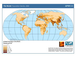 |
Gridded Population of the World, 2000 Web site |
One early user of GPW was Professor Jeffrey Sachs, now the director of the Earth Institute. His paper with Andrew D. Mellinger and John L. Gallup, “The Geography of Poverty and Wealth,” published in Scientific American in 2001, analyzed the location of poor people based in part on the GPW subnational population distributions. Now in its third version, GPW is used regularly not only in natural, social, and health science research, but also in popular atlases, textbooks, Internet maps, news articles, and even art exhibits.
CIESIN was also one of the first groups to make the power of a relational database available online. For our Environmental Treaties and Resource Indicators (ENTRI) database, we developed a Web-based query interface to enable online access to data on the status of international environmental treaties. Before ENTRI, queries had to be sent to a person in Europe who would manually query a desktop database application and send the results back by regular mail or e-mail. ENTRI also enabled users to filter and compare treaty information with data on the environment and natural resources from the World Resources Institute (WRI). We are now in the process of re-engineering ENTRI for a third time, working closely with the Environmental Law Centre of the International Union for Conservation of Nature (IUCN) toward achieving the “network” part of CIESIN’s vision (see news announcement).
By the 1990s, CIESIN’s focus had turned more often to making scientific data more accessible, as in our early efforts to put spatial data for the US, Mexico, and China online, both as data files and through interactive applications. CIESIN was also widely recognized for its development of interoperable data catalogs, rescue of data at risk of loss, and preparation of integrated data sets for cross-disciplinary analysis, e.g., for the State Failure Project sponsored by the U.S. intelligence community.
CIESIN’s move to Palisades, New York in 1998 to become part of the new Earth Institute at Columbia University and the Lamont Campus community has strengthened our efforts in several complementary directions.
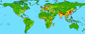 |
| Map of Disease Hotspots: “Global Trends in Emerging Infectious Diseases” Study |
First, we have deepened our interdisciplinary research and education activities, taking advantage of the unique scientific capabilities and instructional resources at the EI and Columbia, and in the New York metropolitan area. We are now actively engaged in collaborative research projects on a wide variety of topics, including environment and conflict, emerging infectious disease, land use change and migration, disaster risk management, urbanization and health, and climate change vulnerability and adaptation. We support numerous student internships, host many visiting scholars and postdoctoral fellows, conduct scientific and technical training sessions around the world, and regularly teach interdisciplinary courses at Columbia.
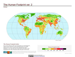 |
Second, we have established a strong track record in addressing pressing needs for policy-relevant data and information. Examples include our work with Yale University on indicators of environmental sustainability and performance, our collaboration with the Wildlife Conservation Society to develop the “Human Footprint” and “Last of the Wild” data sets, our contribution to “research translation” activities with Columbia’s Mailman School of Public Health, and our support for the Intergovernmental Panel on Climate Change (IPCC) Data Distribution Center. Our Natural Resource Management Indicator (NRMI) is one of a number of criteria now used by the Millennium Challenge Corporation to determine eligibility for U.S. development assistance. Our work on hazards with the EI Center for Hazards and Risk Research has influenced disaster risk management at the World Bank.
 |
CIESIN’s environmental sustainability and performance activities featured in an article in Sensing Our Plant, on the Web site of NASA Earth Observing System Data and Information System (EOSDIS) |
Third, we are still very much engaged in applying information technology to make data more accessible and usable, especially in the long term. We are an active University member of the Open Geospatial Consortium (OGC) and are implementing OGC-compliant technologies in support of the NASA Earth Observing System Data and Information System (EOSDIS), the National Biological Information Infrastructure (NBII), and the planned Global Earth Observing System of Systems (GEOSS). We are working with the Columbia University Libraries to adapt new digital object management systems to support long-term stewardship of scientific data. We are helping to lead an international working group of CODATA to utilize remote sensing, Global Positioning System (GPS) techniques, and Internet-based “crowd sourcing” to improve data on inter-city road networks in developing countries and other parts of the world, valuable for agricultural planning, humanitarian assistance, health care delivery, and other applications. We are also contributing to a new international initiative to improve the quality and accessibility of soil data for Africa and the rest of the world.
Our current portfolio of activities builds on but remains true to CIESIN’s original vision for integrating distributed Earth science data with other types of data and information, and applying these to real-world problems using the best available science and technology. As we look back over the past twenty years and consider our prospects for the future, we continue to fine tune our strategies and focus—and terminology—to address the most pressing needs related to sustainable development and a changing global environment; to support the University’s mission to advance knowledge and learning; and to deal with the rapid evolution of science, information technology, and society. The 20th anniversary events we are planning for fall 2009 will be an opportunity to celebrate two decades of accomplishments and discuss new directions and approaches with the wide community of users of our research and data outputs and our broad network of partners, alumni, and friends.
Bob Chen
March 6, 2009
|
This page last modified: Mar 08, 2013
|